My Personal Weather Station

Weather at Boston, Logan International Airport, MA - via NOAA's National Weather Service

Current Watches, Warnings and Advisories for Massachusetts Issued by the National Weather Service

Wednesday, July 20, 2011

7/20/11 Excessive Heat!

An Excessive Heat Watch is in effect. As eluded to last week, the Bermuda High has set up, extending into the central US. This high pressure will allow temperatures to rise into the 90's with an increase in the dew point. This combined will give a heat index in the Boston area of around 100 degrees. This heat will last into Saturday when a cool front from Canada will bring a temporary relief in dew points. The heat however remains building in the plains and will return next week.

One relief, albeit small will be a strong breeze to help remove moisture away from your body, but it will be a hot wind.

With such temperatures and humidity, nighttime lows will not fall far and  expect some areas to remain near 80 on Thursday night.


Heat Index Map for Thursday. Much of the eastern US will have high heat indices. Dark ORANGE = 97+
The heat index is what the temperature feels like on the body when you take the temperature and dew point together.  A high dew point means that it is harder for moisture (sweat) to evaporate off of your body and you can feel hotter and your natural cooling system will be overworked if exerted.  See example below.

Today's High Temperatures- Coolest at the Cape, Islands, Gloucester.
In for the first heat wave of 2011!
 Example:

A temp of 95 with a dewpoint of 74 on Friday will give you a Rel Humidity of 51%. In the summer that will feel very hot. Keep in mind, for example. Your body will "feel" to only cool to 74 degrees and only 50% of the sweat on your body will evaporate.(if the dew point were 58 as it were this past Sunday, you would have 29% humidity 71% of your sweat would evaporate and your body could feel like it cools to 58 in a breeze.

Monday, July 18, 2011

7/18/11 Wicked Hot

Ok, so we will not be experiencing the type of conditions out in the plains with heat indices in the 120s, however our first heat wave (3 consecutive days of 90+ temperatures) may occur by late week.

Today - Severe weather is the main concern for the afternoon with wind damage being the biggest factor, followed by hail and a small threat for tornadoes is possible across New England today.  It will not be an outbreak like June 1, however some areas will see very intense storms. Todays storms should resemble bow echo type storms with strong straight line winds.

A line of showers and storms across NY this morning will trek into the state by late morning and could spark off some thunderstorms.

The biggest threat of storms lies later today between 4 and 8 pm. With a humid airmass in place expect heavy down pours as well.

Friday, July 15, 2011

7/15/11 Hot & Humid Returns

After a nice return to drier air and comfy temperatures, it will once again feel like summer come late Saturday into Monday. 

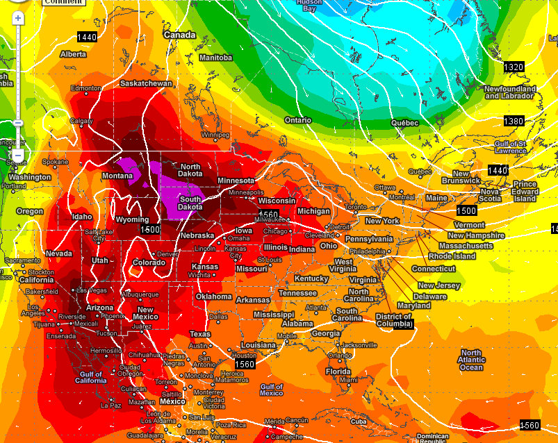
The map below shows the heat (Red & Purple) building in the plains and Rocky Mountains nudging into New England by Monday.  Cooler air will try to work in by Tuesday (Blue & Green) from Canada. However that cool spell will be short lived as the heat builds more and more and will be pushed eastward to New England, where we could experience a heat way by late next week (3 days 90+).

Monday's overall temperatures. Heat builds in the west, cool air tries to work in from Canada for New England, lasts 2 days then the heat returns.

Pleasant on Friday and Saturday with increasing humidity late. Hot and humid on Sunday with possible severe thunderstorms on Monday.

Tuesday, July 12, 2011

Bear Week Forecast - Tuesday Update

Look for it to be a humid day today. High dew points and lots of sun.

Chance for an afternoon thunderstorm between 4 and 6 PM, will be brief. 

Any rain will make it feel more humid later today.

Fog overnight.

Cooler and drier tomorrow! Sunny. Possible afternoon shower.

7/12/11 HOT!!!!

The hottest day of the year so far in Boston.

Expect some scattered showers and thunderstorms between 3 and 6 PM this afternoon.

Cooler at the Cape.

Monday, July 11, 2011

Bear Week Forecast - Monday Update

Hope you like to sweat!  Well at least for the next 36 hours, it will be downright humid and quite warm. Replenish with lots of water and non-alcoholic beverages to keep from dehydration.

Monday's Forecast. Mostly Sunny High of 83, Humid. Low of 70

8 AM - A few clouds, fog.  73

10 AM - Sunny 75

12 PM - Sunny 79

2 PM - Sunny  82

4 PM - Sunny 82

6 PM - Sunny  79

8 PM - Sunny 74

10 PM - Clear  73

12 PM - Clear  71

2 AM - Clear 71

Sunset - 8:17 PM   High Tide -  8:55 PM  Low Tide - 2:38 PM    Water Temp - 67F


Tuesday Outlook  A Very Humid Day, High of 83, Low of 69

Not a bad day overall, showers and thunderstorms move in around 7 PM and last until 11 PM at the latest.  

8 AM - Early fog,Some clouds, mist or drizzle  73.

10 AM - Sun and clouds  77

12 PM - Mostly Sunny 80

2 PM -  Sun and clouds 82

4 PM -  Mostly Sunny 82

6 PM - Cloudy  79

8 PM - Thunderstorm likely  73

10 PM - Rain/ Showers ending 72

12 AM - Moon and Clouds 70

Wednesday - Mostly sunny, not as humid, High of 78!

7/11/11 Back to HOT!

At least here in New England we are offerred a day or two of relief from hot and humid conditions, where places like Savanah, GA have had 52 days in a row of 90 degree weather. Looks like we will be hot and humid today and tomorrow you may feel like you are in Georgia or Texas, but by Wednesday, the comfy air returns for a few days.

Today - A south wind will dictate your temperatures. Inland areas will reach 90 degrees. Coastal areas will reach the lower 80s and locations on the immediate south shore and cape will be in the upper 70s to near 80. Sunshine and humid.


Tonight - Downright humid, sticky, humid muggy weather. With a low near 72 across the region.

Tuesday - Similar to today, but more humid.Morning fog. Highs in the lower 90s inland, mid 80s at the coast and upper 70s to near 80 on the South shore and Cape. Chance of showers and thunderstorms between 3 and 7 PM.

Wednesday - Less humid and comfy! Sunny High of 83.


P-town forecast to come soon!