My Personal Weather Station

Weather at Boston, Logan International Airport, MA - via NOAA's National Weather Service

Current Watches, Warnings and Advisories for Massachusetts Issued by the National Weather Service

Wednesday, May 16, 2012

5/16/12 Summer Thunderstorms Possible today

Scattered Severe Thunderstorms are possible today primarily west of Boston in Western and Central MA, NH and northern CT away from the influence of the ocean air. The primary threat today will be hail and strong straight line -bow type winds and heavy rain. As with any severe weather event a tornado cannot be ruled out, but conditions do not favor rotation of storms today.
1 PM today, some thunderstorms may develop along the Northshore. 

A thunderstorm set up today, as the rain will push away from the coast. The factor for how strong the storms across MA will get is when the low clouds break away over New England. With such situation. The sun acts as the energy source to promote thunderstorm growth. The more sun and heating of the day, the stronger the storms can become. Therefore, if the clouds break away along the coastline BEFORE 11-12 today, there is the chance for a pop up, isolated thunderstorm before the main line arrives later this afternoon.


A line of thunderstorms will move out of NY into New England around 4-5 PM today. Heavier storms are also possible in Northern Vermont, NH and Maine as well. A sea breeze will likely keep any severe weather limited along the MA coastline, however a pop up thunderstorm is still possible on the Boston area.  If you are curious you can view the model run here to see a loop 
An image to show where to expect heavy downpours associated with Thunderstorms. Most of the activity will be in Central and Western MA today. The RED indicates the current time give at 7 PM tonight and the Green indicates a time 90 min prior at 530 PM.  Note the BOW echo nearing Worcester. Strong winds could be possible.
After today, a great stretch of sunshine and mild temperatures return through early next week with mild days and cooler dry nights.


Tuesday, May 8, 2012

5/8/12 A very unsettled weather pattern remains for May

Someone told me yesterday, "Why can't the weather be like it was back in March?"  Remember the stretch of sunshine and warmth.

 May is looking very cool and wet for New England and the pattern does not seem to change in the next 2 weeks. With the exception of this weekend where dry air and some sun will make for a beautiful May weekend.
A main area of low pressure will remain over the Northeast US for much of this week bringing clouds and rain showers into New England. Another area of low pressure over Minnesota (1), will join with this low and keep the clouds and rain around for Wednesday into Thursday. And a 2nd low, over Texas, will track across the south and then up the east coast and bring a chance for heavy rain especially along Eastern Mass Thursday into Friday morning.  High pressure over Montana will move in later Friday into the weekend to bring sunshine and gradually warmer temperatures.
Rainfall forecast up to 6 PM today. Heavy showers will fall across NH and VT, where eastern MA will see roughly 1/4" and the cape only a light shower.  The rain will be around through Friday morning however.

Heavy rain will fall Wednesday into Thursday across Cape Cod where up to 3" of rain could fall total. Boston will likely see up to an inch of rain.


(had to revert for older graphics for today for time)

Sunday, May 6, 2012

5/6/12 Lack of posts.. and Wet wet wet...

First of all I would like to apologize for the lack of posts this past week. A new job has limited the time to prepare a forecast properly.

To make a good forecast for this blog, usually takes a minimum of 1 hour and sometimes up to 2 hours PLUS, depending on what is going on. 

So what is going on?   Briefly, the pattern that had been persistent from last Fall, through the winter into early April has shifted and we are now in a flow in which the storm track tends to be directly over us, or even to the south of New England.

It is something I like to refer to as the "roller coaster effect"

You can think of the jet stream as a roller coaster track, with the storms going along. New England just happens to be in the dip of the track so everything just pours into the region, the wet and the cool weather. 
A weak front will help usher in some drier air today on Sunday, but with a lot of moisture in the ground from days of rain, the sun will help produce some clouds before there is enough drier air to overtake the moisture.  The weak stationary front to the south will be a focus for the storm track later this week as mid week looks wet.

Friday, April 27, 2012

4/27/12 Freezing Tonight.. bundle up the plants!


The remnants of the past weeks Nor'Easter will finally be pushing off the Maine coast today, as a cold area of high pressure takes control over the northeast US.

The old Nor"Easter which has kept our weather unsettled over the past week will finally be kicked out to sea today, as a cold area of high pressure moves in!
With cold high pressure moving in overnight tonight, a FREEZE WARNING has been issued for much of Southern New England, except the immediate Boston area, the Cape, Islands and Providence, where Urban Heating and Ocean temperatures will keep temperatures above freezing.

* TEMPERATURES...IN THE UPPER 20S TO LOW 30S.

* TIMING...MIDNIGHT UNTIL 8 AM EARLY SATURDAY MORNING.

* IMPACTS...THESE CONDITIONS COULD KILL CROPS AND OTHER
  SENSITIVE VEGETATION.

PRECAUTIONARY/PREPAREDNESS ACTIONS...

A FREEZE WARNING IS ISSUED WHEN FREEZING TEMPERATURES ARE
FORECAST TO THREATEN OUTDOOR PLANTS. THOSE WITH AGRICULTURAL
INTERESTS IN THE WARNING AREA ARE ADVISED TO HARVEST OR PROTECT
TENDER VEGETATION. ALSO...POTTED PLANTS NORMALLY LEFT OUTDOORS
SHOULD BE COVERED OR BROUGHT INSIDE AWAY FROM THE COLD.
 
Cool, but sunny conditions will prevail for the weekend, and a gradual warm up is 
forecast for next week 


Tuesday, April 24, 2012

4/24/12 The Aftermath of a Nor"Easter

An unsettled weather pattern will be with us over the next week.  With the passage of the Nor'Easter yesterday, residual clouds and showers will remain for the rest of the week along with some cooler air.

Our weather pattern can be seen on this mornings satellite image. As the low spins over Ontario, it will take several days to move east and will spin in a mix of sun and clouds over New England.


A simplified view of the weather for the next week.  Warm high pressure will keep the south, Mid Atlantic and Ohio Valley in early Summer warmth, while a small battle zone will set up between New England and the Mid Atlantic and on the north side, cooler weather will prevail as winds come in from Canada. Although it will not be COLD, highs will be normal, near 60 with the chance of passing showers, primarily along the south coast.
Much above normal temps are seen over the Ohio Valley. The Northeast remains near normal.
The week ahead will be tough to forecast when you can expect sunshine and when you can expect a rain shower.


Sunday, April 22, 2012

4/22/12 Major Storm to Move Up the Coast.

A late season nor'easter in set to cause some problems across the Northeast and into Appalachia overnight tonight and Monday.

For the Boston area, a cold front will struggle to push through Massachusetts and become stalled through the center of the state. This will be a focusing area as a developing low pressure over the Gulf of Mexico and Florida will move northward bringing heavy rain and winds.

It will be too warm in much of New England so expect heavy rains, however, further west into New York and PA, cold air will work in as another low over Iowa merges with the Gulf low and will create a damaging late season snowstorm, where over a foot of snow could fall .

Storm is similar in nature and structure to that of the Great Blizzard of 1993, with the exception of cold air in place due to time of year.
Impacts for the Boston Area:

  • Heavy Rain thru Monday afternoon up to 3-4 inches possible
  • Flooding of small streams and poor drainage areas likely
  • River flooding not expected due to dry winter and spring and drought conditions
  • Strong winds along the coast up to 40 mph
  • High surf possible.

Friday, April 20, 2012

4/20/12 Sunny, mild weather can be boring...

One of the biggest complaints from the general public about meteorologists is: "They get paid to lie and they are always wrong".  Well this week in point, I was wondering, how many of you thought, "The weather was horrible", "Or, those weathermen, all they said was sunshine and warm..(enter favorite curse)".   This is what tends to happen, when the weather is good and you have no interferences with any plans whether it be driving, a walk, or running a hot marathon, frankly it does not bother you.  It is what follows in my forecast that will then get you upset or make you a bit more weatherwise!

Enjoy the spring and summer like weather for the next 2 days, by Sunday, a potent Nor'Easter will track up the east coast to  bring wind and rain and cooler temperatures into the middle of next week.

Today - Bright sunshine, southwest wind around 8-15 mph will keep the sea breeze at the immediate coastline.  Highs near 80 in the Merrimack Valley, Mid 70s Boston and upper 50s to 60 Cape and Islands.
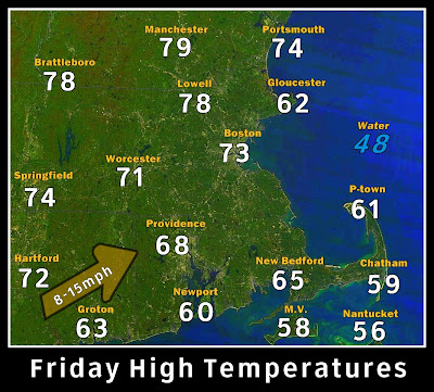
South facing coastal areas and the cape and Islands will be the coolest including Cape Ann today.

High pressure today will bring in a warming Southwest wind.  A cold front and Low over the Gulf will be our weather late on Saturday and into next week.


On Saturday - a mix of sun and clouds along with some fog will start the day as a cold front approaches but never reaches eastern New England. A south wind will still keep temperatures mild into the 70s. It should remain mostly dry until later afternoon.

The front is seen stretching from the Gulf of St Lawrence to Georgia and  low developing in the Gulf of Mexico on this forecast rain image.

Late Saturday into Monday - The cold front gets hung up over western New England as a major storm develops in the Gulf of Mexico and this storm helps push the front back to the west and will also be a focal point for very heavy rain with 1-3" of rain falling.


By Monday, the low and the front merge over New England to bring heavy rain and winds over New England on Monday. (A potent snowstorm could set up in the higher elevations of New York and even PA)