My Personal Weather Station

Weather at Boston, Logan International Airport, MA - via NOAA's National Weather Service

Current Watches, Warnings and Advisories for Massachusetts Issued by the National Weather Service

Thursday, February 12, 2015

Why the snow in Boston is Not Climate Change Enhanced Snow -

A recent article is making headway across social media about all the snow in Boston - simply saying "Climate Change is to blame".  Nothing infuriates me more than blanket statements that something other than the established weather pattern caused a weather event or that when a weather event has happened before in the past it has to now be extreme, but what infuriates me even more is when the information is a blatant lie or severe misuse of information to garner an attempt to make a statement. That is what is happening here.

First some basic facts about the past few weeks in Boston. (From the NWS)

1.  The overall temperature since January 26 (The first Blizzard) have been well below normal. In fact roughly 10F below normal.

2.  The liquid (melted) equivalent of precipitation that has fallen in Boston since Jan 26 is around 3.64"

Meteorologists often use a snow ratio to predict snowfall. Commonly this ratio is 1:10 - for every 1 inch of liquid precipitation approximately, 10 inches of snow will fall.  This ratio is great for when the air temperature is around 30F.  If so, we would have seen snowfall in Boston be 36.4" since January 26.

This ratio increases though as temperature decreases. So if the temperature of the air is around 20F, which it has been in most of our snow cases this ratio increases to 1:20. Now with this basic science and math we would get 72.8" of snow. If you have noticed, the snow is lighter and fluffier.   Now we can agree that the temperature has not been constantly 20F, but it has been below the normal of 38/24F.

So right here, we have basically proven that because the air temperature in Boston has on average been 10F below normal our snowfall rate has increased to almost 2x what should be expected.  Most climate change articles do not point this out. 
ScreenHunter_7069 Feb. 11 11.02
The colder the air temperature is in Boston the more snow will fall 

Next.. in a recent article, a statement "ocean temperatures off the East Coast are exceptionally warm, some 21 degrees warmer than normal in some areas" .  This comes directly from Penn State Climate scientist, Michael Mann.  This statement was just gasoline being poured on any climate change argument, and was picked up by so many other climate change scientists who made simple statements to grab attention.  But the fact is, Dr. Mann's  (11C heat) was a pixel of warmth detected in the ever flowing and changing Gulf Stream placed on a 30 year normal smoothed map of the Gulf Stream and picked to be a major heat burst.  Anyone can take a piece or fragment of data and manipulate it to fit your theory. In fact, many meteorologists have scrutinized this number and can only come up with a 5C temperature anomaly in the ocean at the given point.  
(It must be pointed out that unlike a hurricane, the eye or center relies heavily on the surface water temperature directly under it for strength - a winter storm relies on temperature differences across thousands of miles both on land and sea)

So lets look at this a bit closer. First with an analogy.

Everyday, many commute into Boston - lets say its by car down I93.  You leave your house, you get on the side road, you stop at a stop sign or red light, traffic is flowing you reach 65mph. You hit stop and go traffic until you get into the city. You park.  If you were to average out your entire commute you may come up with an average (normal)of 30mph.  Is this to say that you constantly drove 30mph. Absolutely not. You went 65mph at one point, you went 5mph at one point well above and below your average.  So I cannot say to you, you drove 35mph above average the entire time if I somehow pinpointed your speed at 65mph on a map. 

The same applies to climate and in the Gulf Stream.  Eddies in the Gulf Stream are constantly moving, some are warm, some are cold.  When you place these temperature differences on an averaged map, you will get an anomaly for certain.  Tomorrow, that 21F  above normal eddy could be 10F colder than average on that spot, because the Gulf Stream is always moving.    

Next, we need to be level headed about our science as well. The ocean temperature in Boston Harbor is around 34F right now. Off the coast, about 43F.  If what was published was a true statement, then Boston Harbor should be 55F and off the coast should be 64F right now in temperature. We would be lucky to even see this in the heat of summer for our latitude. BUT since our temperature readings indicate the current temps of 34 and 43, Dr. Manns assertion that the temperatures are 21 degrees above normal mean that Boston Harbor water temperature in Febuary is 13F and off the coast 22F.  Ocean water freezes at around 27F.  Simply his statement cannot be held up to phyisics. 

ScreenHunter_7074 Feb. 11 22.30
ScreenHunter_7073 Feb. 11 22.28

Where I will concede is that all temperature data over the Atlantic Ocean is running about 2F above normal.  The oceans go through cylces of warm and cold and this warm cycle is expected to last another few years. So this leads to the question of moisture in the atmosphere. The articles specifically stated that a warmer ocean will increase moisture in the atmosphere, increasing the amount of precipitable water to fall out, therefore increasing snowfall rates. Or - because the air is SO much colder and the water is so much warmer the evaporation rate is much greater and you will get greater amounts of snow to fall. I have yet to see or hear that precipitation is well above normal. Single storms in any season can produce over 1 inch of rainfall.   So you need to ask yourself.  If it rained on Sunday (8th) 0.37" and Monday (9th) 0.88" (which is the liquid equiv of what fell) would you be screaming climate change caused this to happen? 

Boston is a coastal weather community, influenced by the ocean, by the continental airmasses from the Arctic, and by plumes of moisture from the tropics and by wind blowing in off of the ocean.

This year it was Bostons turn for snow. Just as in 2010 it was Washington DC, Remember that?  Or how about the Blizzard of 78, or think about the snows that fell to depths of 24"
inches in the south in 1973. Or Wilmington, NC in 1989.  Every area of the country sees a winter weather outbreak at some point.   But why not NYC, just 180 miles away, or even Western Massachusetts, they have been immune to heavy snows this year. Does Climate Change pick a city and say, lets target Buffalo and Boston this year, but leave NYC alone?

Is climate change real, yes it is. Climate change is something that has been happening for millennia.  We have had ice ages, we have had warming spells.  There are cycles in the earth and in space that we have yet to uncover of fully understand, but if we look back at our own human history here in New England to 1630.  We can find events that are similar, or even much worse than what are experiencing now.  This is why I doubt the cries of the climate change activist. Not because I don't care about the planet or environment, it is because this has happened before and will happen again. 

I must also inform you the reader, that I am not getting paid to write to article. However, many of the climate scientists writing these scare terms are getting $$$ of funding to support them and make the relevant.  If my livelihood and professional occupation were solely based on grants and funding that expected me to prove a point, I would definitely make the data say what I needed it to say.  Or just tweet "Climate change responsible for Boston snow - 11C above normal water to blame".    Today, that gives you an edge and makes you relevant to be put into national publications, invited onto talk shows in major markets and when my employer sees  this or a big grant giving foundation sees this, I get more money.  I am not a die hard right wing conservative either.  My own professional research has allowed me to question what is being told.

I hope this writing gives you a sense of reality of the overall scheme of what has been happening weatherwise in Boston.  You may choose to not accept it, or your political affiliation may place you against it. That is fine with me. I offer you my opinion based on the facts presented. 

Tuesday, April 2, 2013

4/2/13 Here comes Spring!!

You asked for it!  You wanted it Boston and New England!     A major pattern shift will finally kick the cold air out of the northeast and bring temps back into the 50s by later this week.

Next week, we could be approaching the 70s by Tuesday and perhaps some areas touching 80 by the end of the week.   Just a trend, but Spring looks to have sprung!  It will be getting a tad bit humid too.

Of note:  A cool down comes for mid April, but nothing as cold as it has been!


Friday, February 8, 2013

2/8/12 The Blizzard of 2013 Update 1

Welcome back to the WxBear Blog.    

With a storm such as this, when the extreme is about to happen, sometimes it is easier to just say, PREPARE for the worst.


This image above from the NWS - Boston is very well done and in line with what I would come up with on my own.

Here is what you need to take away if you live in Boston.

  • Snowfall  -   20-28" of snow.  Locally higher amounts, less just at the coast
  • Wind - Getting up to 30-45 mph, much higher near 75 Cape and Nantucket
  • Coastal Flooding -  2-4 foot storm surge.  Overwash 9pm & 10 AM likely 

If you want a more detailed snow map, here is one.


Map showing the very strong storm, with a calm center, Nantucket, may go calm. This is the sign of a very strong intense storm.   The dark colors are wind.
  Winds around the center of the storm rotate counter clockwise along the lines of equal pressure.  Showing a very strong East Northeast wind.

Saturday, November 3, 2012

11/3/12 Potential Severe Nor'Easter to impact Sandy areas

A significant Nor'easter is shaping up for later mid week.

Right now it is too early to say the direct impacts, here are some details.

  • Significant Snow in New England
  • Light Snow in Boston, NYC
  • Coastal Flooding possible
  • Winds - Gale to Storm force possible  (30-60mph)
The weather map for 7 PM Wednesday showing a strong storm south of Cape Cod.  Colors on this map indicate wind speed. A strong North East wind will impact New England with high gusts and strong waves prompting some coastal flooding.

SNOWFALL

The first significant snow will fall across the higher terrain of New England with over a foot possible in the Berkshires.

I would not yet be confident in an exact forecast, but take with this the following:

  • Purple -  general coating to 3"
  • Blues - 3-6"
  • Oranges - 6-12"
  • Deep red - Over a foot"

Also, Sunday night will feature a widespread freeze across ALL the Boston area, Expect any remaining outside plants to freeze and if you have yet to do so, prepare for winter now.

Friday, October 26, 2012

10/26/12 Please take serious read about Sandy

I know you want to know where Sandy is going and what will happen for you?

There are 2 main scenarios as to where Sandy is going to go.

2.  Sandy makes a very hard left toward the NJ, Delmarva coast. ( discussed later)

1.  Sandy still turns left, but gets a bit further north and tracks WEST along the Southern
     New England coast.


Lets take a look at # 1.   (for my MA friends)

This idea scares me so much.  Most everyone reading this will not even be able to comprehend what could happen in this type of situation. 


Hurricane Sandy in this scenario runs up the coast but come back west toward the SE Massachusetts coastline by 8 AM Tuesday morning. 

Sandy then either skirts the south coast into Long Island or NYC. What is frightening is that in all of history, most hurricanes are coming at New England from the south and moving Northeast.  Sandy will NOT be doing this

Sandy will be coming at New England from the North West.  The worst part of Sandy will be her right front quadrant relative to storm motion. Wind will pile waves

For Boston tho:

  • Possibly 6 hours + of hurricane force winds ( Green area)
  • Coastal Storm Surge 3-6 feet. Cat 1 or 2.
  • Waves 30+feet 
  • Rainfall 

If you are concerned about where you live, check out the maps at this link http://www.iwr.usace.army.mil/nhp/HESfacts.cfml?pgid=109

each town, or region is mapped out to show you the effects of storm surge in your area. Prepare now!!  

Winds -  the scariest situation I am seeing is both storm surge and WIND.   One of the computer models is suggesting that 115 mph wind speeds will be just above the surface (indicated in the browns on the map below)  Since Sandy will not be in a true tropical state, these winds could mix down to the surface at any given time.   Note too the wind field with Sandy it HUGE!   Gales extend from South Carolina to Nova Scotia and back to Ohio and Ontario!


If you want to see what Sandy could be capable of doing, watch this video from 1938.

http://www.youtube.com/watch?v=7b21g-5YBLs

Follow these tips to prepare yourself.

http://www.mass.gov/eopss/agencies/mema/mema-offers-tips-as-hurricane-sandy-approaches.html


Monday, October 22, 2012

10/22/12 Halloween Storm Sandy

There is some hype going on about the potential for a major storm event to take place beginning later this week.

Right now, an area of low pressure is developing over the Caribbean Sea.


The low will be slow to move northward and will be in the Bahama's , later this weekend. If named it will be Sandy.

For New England - the weekend looks sunny and mild.

Then next Monday - all of the east coast from North Carolina to New England needs to prepare for a late season, prolonged deluge storm. 

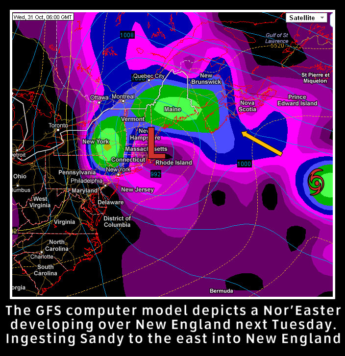
Interestingly, the GFS ( a computer model) has a Grace/Perfect Storm set up this morning. With a Nor'easter developing over New England, ingesting the moisture from what could be Sandy.

Although it looks not as mennacing as what will follow, the models keep this low/Sandy spinning off the New England coast for 6 days. This could bring a lot of wind, erosion and more.


A more intense situation lies in several other model outputs showing Sandy tracking up the east Coast.  The Nor'Easter still develops, but instead, keeps Sandy as a separate entity and merges the two into a powerful storm over the mid Atlantic and North east next Tuesday into the week. 


There are some discussing a similar weather pattern setting up to that of 1954 and the infamous Hurricane Hazel.  The initial pattern looks similar, but in this case, Sandy then could get trapped in or just off the Northeast.


Monday, September 3, 2012

9/3/12 - Tropical Impacts for New England - Next Week.

1st -  Let me apologize for being absent for much of the summer. I have been embarking on a new career path that has taken up a lot of my time. However, I still would like to present important weather information seems appropriate to you, however, at this time a daily forecast cannot be made. When the business aspect takes off, then I hope to be able to do a little bit of both!

2nd - The time has come to update you a possible impact from Tropical Cyclone Leslie.

An interesting meteorological pattern may be setting up, one that we saw in 1989. 

Hurricane Leslie is expected to pass near Bermuda later this week. Typically this track means clear sailing for much of the United States coastline and only a threat to Atlantic Canada.

However, some changes are occurring that are having some meteorologists rethink the eventual track of Leslie.

A trough of low pressure that was forecast to develop and pick up and kick Leslie out to sea, will appear to be actually closing off over the Southeast US.   This will act, instead of a kicker, as a pull system and pull Leslie closer to the US Coast.

As was the case with hurricane Hugo in 1989, the track, not seen brought the hurricane in on a direct path into SC.    This will not be a Hugo, however, what I am seeing is a storm that could be pulled closer to the US coast as it passes by Bermuda, an unusual pattern.  This has been coming to light throughout the day today.  

The worst case scenario now could be that Leslie tracks very close to the Outer Cape (Cod) on Tuesday of next week as a very strong hurricane. Some models are bringing this to a Category 4 near Bermuda.   The track could change of course, and I will keep you posted on any changes!   The least worrisome at this moment will still possibly bring some windy conditions to eastern New England, high seas and a possible shower closest to the coast.


Model Weather Map for Tuesday, Sept 11, 2012..  Leslie is very close to Cape Cod in a worst case scenario.  This may change, but it is something to watch.

Friday, June 29, 2012

6/29/12 Hot weather returns

A heat wave is expected to invade the Boston area this weekend (3 or more days above 90).

The massive heat that has been building in the Rockies and south will move in today and stay with us until Sunday, when a bit of a cool down back into the 80s returns for the holiday week.

It will be coolest along the coastal areas and south facing beaches today.
For today, Friday, a few scattered showers and thunderstorms will move through during the morning hours, then reform later in the day. Expect mid 90s in most places, except upper 80s at the beaches with upper 70s to lower 80s on the Cape. Dew point levels will be dropping today, so it will not feel as humid today or tonight, but will rise over the weekend.

Our heat today is being transported in around a very HOT high pressure to the south. The flow for New England will be mostly west though so the extreme heat remains south.
Scattered Thunderstorms are possible each day, but no areas of organized rain is expected.

Monday, June 25, 2012

6/25/12 Cold then back to summer heat. Rain today!

A strong cold front is pushing its way across New England this morning that will bring heavy rains and thunderstorms across the region as the morning progresses.

Forecast radar image for 11 AM this morning, with one heavy band of showers and thunderstorms moving through Eastern MA.

As the front moves through, over an inch of rain could fall from the storms.  An area of low pressure will form just off the New England coast and will keep the rain from moving too far offshore and keep the clouds around more much of the coastal areas.

Tuesday looks to be a very cool and damp day with a few breaks of sun from time to time especially in southern locations.

Temperatures on Tuesday will be 10-12 degrees cooler than normal.  As the area of low pressure off the coast spins, it will allow for clouds to rotate around it and make for a cloudy day except for the southern parts of New England.

The cool is short lived once again and heat will return for the weekend.

Heat will build across the south east and move into New England for the weekend with temperatures getting into the upper 80s and lower 90s.   It will once again be short lived as a cold front will push through late Sunday into Monday.   Debby will be a slow mover off the FL coast.


Tuesday, June 19, 2012

6/19/12 Get Your A/C's - Summer is coming!!

Yes!  Summer will arrive tomorrow and the weather will also reflect summertime heat. The cool weather of the past few days will be pushed away as heat and humidity return for a full blast of HOT HOT HOT!!
How it will feel tomorrow afternoon


The heat will only last until Friday, as a another shot of cooler air moves in for the weekend.

However, it will remain extremely humid Wednesday and Thursday night with temperatures only falling into the upper 70s and it will be extremely sticky!   If you need an A/C  get it today before the stores have a mad rush on them!


Tuesday, June 12, 2012

6/12/12 Heavy Rains for Wednesday

So far, the months of May and June have looked, at least on weather map, like March and April. And vice versa.  The map below shows a pattern more typical of Spring than that of entering the summer solstice next week.

The flow between high pressure over Canada and a Low in the Atlantic means sun, but mild conditions will exist along the east coast for several days. The heat it being pumped into the central Plains.  Also very interesting this year, interesting spin ups of tropical type storms may be happening in such a pattern close to the S Coast.  The high moves into Atlantic Canada this weekend, keeping New England dry, but cool.

For Tuesday, a cold front will slowly push toward New England during the day, expect Sun to be replaced with increasing high clouds to all clouds by late afternoon. Rain arrives by 11 PM in the Boston area. Highs in the lower 70s.

Wednesday morning will be a rough go with heavy rain falling in a line from Maine to Long Island.  Up to  a half inch of rain could fall. Heavier amounts over Western New England.

The rain should last for most of the day and taper to showers by afternoon.

After this front pushes through, it will remain well off shore, except for the southern end of it which may Spin up an area of low pressure and track SOUTH as high pressure dominates the east coast. This is an a-typical high as it is coming in from the North Atlantic spreading down the east coast and not a Bermuda high which typically allows warm air to flow north. 

An onshore flow will keep coastal areas cool an a bit breezy, but dry.

This map is difficult to see, but a sprawling area of high pressure will extend from Atlantic Canada all the way to Florida for the weekend.

Wednesday, June 6, 2012

6/6/12 Summer to return this weekend. Major heat next week!

There is a lot to be said about this past weekends weather. The hows and whys of why it got cold are quite detailed and it is not just one simple answer, in fact it is something in meteorology we call, teleconnections.   This means that many small events, all around the globe can react to cause another event.  Like the butterfly flapping its wings effect.  If any readers wish, I will gladly write a post about what happened. So please respond.  Otherwise, lets look ahead, because frankly, you are not planning for last weekend!

The culprit for the cool, wet weather is still seen on this mornings weather map. An area of low pressure over Atlantic Canada. The flow around this low is bringing very cool air streaming in from the cold waters of the North Atlantic into the Northeast.  The Bermuda high has been pushed south. Heat is building in the central plains.
The weekend weather map, shows warmer air building to our west, a warm front will push through on Saturday evening to bring a chance of a shower along with warmer weather for Sunday into Monday.
Next week looks to be warm, followed by a HOT pattern setting up where highs will possibly get into the 90s.


Friday, May 25, 2012

5/25/12 We have a little bit of everything for everybody! Even HEAT!


This Memorial Day weekend forecast sounds more like a forecast one would be making for Labor Day.  Many features are happening on the weather maps and I hope to convey some of them to you below.

This mornings satellite image shows many of the features that will play in this weekends weather as well as into next week. For New England and Boston the focus will be on a cold front that will push north of us today and the high pressure over the south. A tropical storm is likely forming off the Carolina coast today. Each detailed below.
1.  The cold front -  This front will actually push well north of New England into Canada today and on the day Saturday, allowing the area of high pressure to the south to nudge in for Saturday and give us a very warm day.  However this cold front sneaks back down from Canada on Saturday night and runs into this large area of high pressure to the south and gets stuck over New England at least until Tuesday.

2.  The Hot High pressure that will bring heat to the south nudges in for one day of warmth on Saturday bringing temperatures into the 80s. However the front eventually comes back through and turns the winds east off the ocean and pushed the hotter air back to the mid Atlantic.

3. Disturbances will ride along the front to bring the chances for showers each day into Tuesday

4. A tropical storm is likely to be forming (out of season) off the coast of the Carolinas.  The weather pattern can actually be seen in its model track being pushed back south into GA/FL by late this weekend and then eventually up the coastline and out to sea by next week.

If you would like to see the Atmosphere in motion, click HERE and push FWD, very fascinating pattern.. You do not need to be a meteorologist to understand. What you are seeing is the flow of the atmosphere and the pressure (weather systems)


Tuesday, May 22, 2012

5/22/12 RAINachusetts... Yup! More rain. Memorial Day Outlook

Thanks to my friend Mikey for today's headline!  Royalties to come in the mail.

Today's weather map has some great weather features on it, if you are a meteorologist!  Not if you are a fan of sunshine, but have no fear, a big warm up is on the way.

An area of low pressure is slowly tracking up the northeast coast, bringing an east wind to most of NE. This will keep our sky cloudy with scattered showers for most of the day.  The former tropical storm Alberto will track well south of New England and eventually become part of the larger overall low pressure with no impact to land areas.    A cold front will slowly push east and bring the chance for thunderstorms on Thursday.
Scattered rain will be with us for  most of the day today as bands rotate in around the low over the South Shore


Weekend weather map...  High pressure will build across the South pumping heat into the plains and the Northeast. However, a cold front may be hard to displace. At this time, it is too soon to say whether the Boston area will be in the heat or in the cooler marine air.

With the above statement made, the weekend here in New England will end up sunny and hot or cool with some scattered showers.  As the week progresses, we can evaluate the pattern, right now I will go in the middle and not warm us up and keep a scattered shower possible.

Scattered Showers and Thunderstorms are possible into Thursday. A more humid airmass moves in late Thursday in to the weekend.
At this point, most areas will see Sunshine, through the weekend. A possible shower is possible on the Cape on Saturday.

Wednesday, May 16, 2012

5/16/12 Summer Thunderstorms Possible today

Scattered Severe Thunderstorms are possible today primarily west of Boston in Western and Central MA, NH and northern CT away from the influence of the ocean air. The primary threat today will be hail and strong straight line -bow type winds and heavy rain. As with any severe weather event a tornado cannot be ruled out, but conditions do not favor rotation of storms today.
1 PM today, some thunderstorms may develop along the Northshore. 

A thunderstorm set up today, as the rain will push away from the coast. The factor for how strong the storms across MA will get is when the low clouds break away over New England. With such situation. The sun acts as the energy source to promote thunderstorm growth. The more sun and heating of the day, the stronger the storms can become. Therefore, if the clouds break away along the coastline BEFORE 11-12 today, there is the chance for a pop up, isolated thunderstorm before the main line arrives later this afternoon.


A line of thunderstorms will move out of NY into New England around 4-5 PM today. Heavier storms are also possible in Northern Vermont, NH and Maine as well. A sea breeze will likely keep any severe weather limited along the MA coastline, however a pop up thunderstorm is still possible on the Boston area.  If you are curious you can view the model run here to see a loop 
An image to show where to expect heavy downpours associated with Thunderstorms. Most of the activity will be in Central and Western MA today. The RED indicates the current time give at 7 PM tonight and the Green indicates a time 90 min prior at 530 PM.  Note the BOW echo nearing Worcester. Strong winds could be possible.
After today, a great stretch of sunshine and mild temperatures return through early next week with mild days and cooler dry nights.


Tuesday, May 8, 2012

5/8/12 A very unsettled weather pattern remains for May

Someone told me yesterday, "Why can't the weather be like it was back in March?"  Remember the stretch of sunshine and warmth.

 May is looking very cool and wet for New England and the pattern does not seem to change in the next 2 weeks. With the exception of this weekend where dry air and some sun will make for a beautiful May weekend.
A main area of low pressure will remain over the Northeast US for much of this week bringing clouds and rain showers into New England. Another area of low pressure over Minnesota (1), will join with this low and keep the clouds and rain around for Wednesday into Thursday. And a 2nd low, over Texas, will track across the south and then up the east coast and bring a chance for heavy rain especially along Eastern Mass Thursday into Friday morning.  High pressure over Montana will move in later Friday into the weekend to bring sunshine and gradually warmer temperatures.
Rainfall forecast up to 6 PM today. Heavy showers will fall across NH and VT, where eastern MA will see roughly 1/4" and the cape only a light shower.  The rain will be around through Friday morning however.

Heavy rain will fall Wednesday into Thursday across Cape Cod where up to 3" of rain could fall total. Boston will likely see up to an inch of rain.


(had to revert for older graphics for today for time)