My Personal Weather Station

Weather at Boston, Logan International Airport, MA - via NOAA's National Weather Service

Current Watches, Warnings and Advisories for Massachusetts Issued by the National Weather Service

Thursday, March 1, 2012

3/1/12 March blows in... Meteorological Spring Arrives Snow details

As expected yesterday, snow fell across much of the Boston area, but enough warm air moved in to change the snow over to a mix and by this morning, most of the snow that has fallen in the Boston area has melted.  

Areas away from the city, north and west will still be cold enough for snow to fall and not melt as easily.

A rain snow line (RED) will set up today. Any precipitation NORTH and WEST of  line that does fall today will likely be in the form of SNOW. Some snows in this area could be heavy.  This line gradually pushes south and by 8 PM tonight the line (BLUE) reaches Boston. At that time however, the precipitation will be light and only up to an additional coating or inch is likely.


The weather map setup for the remainder of the day shows a new area of Low Pressure forming south of Nantucket. A dry slot (A punch of dry air into the storm) will cut of rain/snow for much of the early afternoon. 

As this low begins to strengthen... it will set up an area of enhanced precipitation and along with some strong winds. This flow will push into far northeast MA and southern NH by mid day and will help drop several more inches of snow along the NH/MA border inland from 495.
The old Low will push through later tonight and usher in some colder air and change any left over precipitation to snow, but it will be light in nature. Up to an inch could fall as this low moves through later tonight in Boston and the South coast.

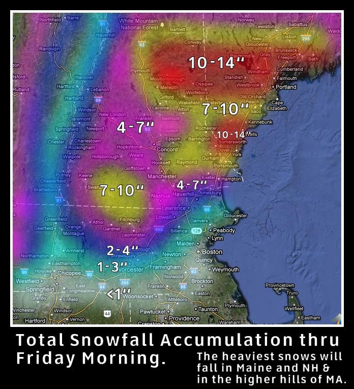
Total Snowfall map as of 8 AM Thursday. (Some snow has melted)
After the passage of this storm, some colder air will be in place for Friday, but will quickly be displaced as yet another storm deepens over the Great Lakes and forces warmer air into New England.

NOTE: If you are in an area where heavy snow falls, the precipitation on Saturday could be a freezing rain event due to the cold air at the surface esp in NH and Maine.

Wednesday, February 29, 2012

2/29/12 Leap Day Snow Storm - The Fine Details

Today's Forecast is extremely tricky. Location will be key as to how much snow falls, what type of precipitation falls and for how long. 

A complicated forecast is determining where the mix line sets up. Current thinking is that this line will move inland a few miles. East of this line, snow will change over the a mix of rain, snow, sleet and freezing rain overnight, lessening and melting snowfall totals.  The line is expected to fluctuate also throughout the event so it may push inland more or come closer to the coast throughout the overnight.
Here is what you can expect for the Boston area thru 11 PM Thursday

  • A light band of snow moves through by 11 AM
  • 2-3 PM Snow arrives in the Boston area.
  • 4-7 PM Snow will be heavy at rush hour commute - heavy snow falls west of City.
  • By 11 PM up to 3" falls across region
  • 11 PM - 8 AM  a mix of snow, sleet, freezing rain and rain begins to fall in the PINK areas all other areas see snow.  This will likely fluctuate throughout the overnight in this area. Some areas west of the rain/snow line may also mix in with sleet to lessen snow amounts.
  • 8 AM - 2 PM  a mix of rain and sleet falls along the coastal areas. Snow continues to fall west especially heavy north of 495 and Worcester.
  • 2-11 PM colder air moves in and any precipitation all changes to light snow, but less than 1" continues to fall
Up to 1 foot of snow could fall in the higher elevations MA, NH and VT with this snowstorm.
Winter Storm Warnings are issued for much of Central New England

This mornings Water Vapor shows an intense low over Minnesota this low is vast and a weak disturbance has pushed eastward over the Mid Atlantic spreading rains and snow across that region. Severe weather with tornadoes have been reported in Kentucky and Missouri, this severe weather will stay south, but gives you an idea of how much energy this storm approaching New England is.


Tuesday, February 28, 2012

2/28/12 Snow is on the way - for some.

Another winter storm is taking aim at New England again during the next 48 hours. And yet again the following factors will come into play.

  • Location 
  • Warm Air Intrusion 
  • Snow/Sleet/Rain Mix
  • Solar Radiation 
First lets look at the total snowfall map...
This map shows the total snowfall forecast for Southern New England thru Friday morning. I would tend to go with the lower amounts and consider some areas may see an initial accumulation but will be limited by sleet and rainfall.
Location -  Areas closest to the coast will see the least amount of snowfall, which also includes Boston the Cape and the South Coast. Enough warm air will work in to the surface from the ocean to change the snow to rainfall or at least a mix.

Warm Air Intrusion - There is not a lot of cold air to work with with this storm, as the coldest air is filtering in from Canada to the East. As the low gets stronger, the flow of air will be from the south and off the ocean so a mix of rain, snow and sleet will move in later on Wednesday. This will limit snowfall amounts.


Rain/Snow Mix - As stated above, this will likely move in and help melt any snowfall that falls, so even if 1-3 inches of snow falls, the rain will likely melt most of the snow, so any areas that see a high amount at first will see it shrink.


Solar Radiation - As we approach March, the sun's rays are getting quite strong and even with cloud cover, the radiation on the roadways and non-snow covered surfaces will help warm the ground and limit snow fall.

Boston is under the Winter Storm Watch for the possibility of snow, sleet and icy conditions. Further inland it is primarily for snows.

Note: If you live in an area that currently has snow on the ground or are well removed from the coast (NH-VT-Western MA) the likely hood of a higher snow amount is greater. 

The suns rays now are similar to  that of Early October!! 


Monday, February 27, 2012

2/27/12 Mild then snow for mid week.

A ridge of high pressure will move over New England and allow a southwest flow of air to boost temperatures to near 50 today for much of the Boston area.

Snow has an impact on temperatures. Where there is snow, the sun's energy must first go to melt the snow and ice. Then go to warming. Where there is no snow, the ground can warm much easier. Since our air will be coming in from the south today, where there is no snow, the sun will heat the land and allow temperatures to warm.

A weak area of low pressure will swing through this evening, bringing some clouds over night and bring temperatures down for the day on Tuesday.


As for the approaching storm for Wednesday afternoon into Thursday.  A potent snow storm is likely over parts of New England. The details on exact amounts of snow and locations of snowfall are not fully known. 

However for the Boston area, it appears that enough warm air will work in to allow for a mix of rain and sleet for Wednesday and Wednesday night.

As the low tracks east on Thursday a brief burst of snow is possible. Heavy snow could fall West of Worcester.


Sunday, February 26, 2012

2/26/12 Expect an active week of weather..

Mother nature I think is a week too early, as the windy weather usually associated with March is here. Then again, nothing has been typical about this winter season.

A 976mb low over Nova Scotia and a 1032 mb high over NC and WV are creating the tight pressure gradient over New England this morning, allowing for windy conditions. As the high pressure moves east the wind will die down. Note the low to the west over SD, this will be our weather maker later Monday night, but will likely bring only a few passing clouds.
The highest wind gusts were at Gloucester and Blue Hill yesterday at 61 mph.  Just of note, Mt Washington gusted to 111 mph.
High pressure will build in for later on Sunday into Monday. Temperatures will remain cool today with highs only reaching the upper 30s to near 40 as the flow of air is in from Canada.

As the high builds to our east tomorrow, a southerly wind flow will allow temperatures to climb to near 50, but the low that is currently over South Dakota will start to bring some high clouds in later in the day. 


As the week goes on, another storm from the Southwest will approach on Wednesday and bring the chance for some snow showers for much of the region. It is too early to say how much may fall. This storm is not well organized and unlike most storms, will be spread out stretching from NY to the coast,
A complicated weather map sets up for Wednesday as a low pressure area moves into New York State.  A weak area of low pressure forms along the coast off of Long Island. The low remains fairly weak however overspreads the chance for snow to fall for much of a 24 hour period. Cold air from Canada will push southward to keep temperatures cool. The question remains, will there be enough moisture to fall and accumulate here in the Boston area, will there be enough solar radiation to promote melting as the rate of snowfall may not exceed solar heating.
More info to come on this storm on Monday and Tuesday


Friday, February 24, 2012

2/24/12 Rain, Thunder, Wind and Snow... Oh My!

A potent spring like storm is spinning this afternoon through the Great Lakes. This low is bringing severe weather and tornadoes to the south. Rain and a possible rumble of thunder to the northeast and will bring heavy snows to the mountains of VT, NH and Maine. Strong winds will move in tomorrow!


As the low continues to get stronger, it will allow for some warmer air to work into coastal New England tonight where temperatures will rise into the 40s.

 Heavy rains and a possible rumble of thunder are not out of the question tonight as the front nears. Especially south of Boston.

Snow will fall throughout much of northern New England tonight with some areas getting near a foot of snow. Boston will likely not see any accumulations and just a flurry or two early Saturday. (This is from an experimental model output for snowfall the HRRR)

Saturday will be very windy with wind gusts approaching 50 mph in Boston and up to 60mph on the Cape, where a High Wind Warning is in effect! Winds will be strongest from the West between 6AM and 1 PM. High temperatures will be in the mid 40s.


...HIGH WIND WARNING IN EFFECT FROM 4 AM TO 7 PM EST SATURDAY...

THE NATIONAL WEATHER SERVICE IN TAUNTON HAS ISSUED A HIGH WIND
WARNING...WHICH IS IN EFFECT FROM 4 AM TO 7 PM EST SATURDAY. THE
WIND ADVISORY IS NO LONGER IN EFFECT.

* LOCATIONS...NORTHEAST CONNECTICUT...NORTHERN AND CENTRAL RHODE
  ISLAND...MOST OF CENTRAL AND EASTERN MASSACHUSETTS.

* HAZARDS...STRONG GUSTY WINDS.

* WINDS...WEST 20 TO 30 MPH WITH GUSTS UP TO 55 MPH.

* TIMING...WINDS WILL BECOME WEST AND INCREASE TONIGHT. WINDS WILL
  CONTINUE SATURDAY WITH SPEEDS REACHING THEIR STRONGEST VALUES.
  WIND WILL DIMINISH SATURDAY EVENING.

* IMPACTS...STRONG GUSTY WINDS WILL EASILY BLOW ABOUT LIGHTER
  ITEMS SUCH AS TRASH CANS. THESE STRONG WINDS CAN ALSO KNOCK DOWN
  SMALL TREE LIMBS AND BRANCHES. WINDS THIS STRONG CAN ALSO MAKE
  DRIVING DIFFICULT...ESPECIALLY FOR HIGH PROFILE VEHICLES. USE
  EXTRA CAUTION.

PRECAUTIONARY/PREPAREDNESS ACTIONS...

A HIGH WIND WARNING IS ISSUED WHEN SUSTAINED WINDS OF 40 MPH ARE
EXPECTED FOR AT LEAST AN HOUR...WITH GUSTS OF 58 MPH OR GREATER
AT ANY TIME.  DAMAGE TO TREES...POWER LINES...AND PROPERTY ARE
POSSIBLE WITH WIND OF THIS MAGNITUDE. POWER OUTAGES ARE LIKELY.
TAKE ACTION NOW TO SECURE ANY LOOSE OUTDOOR OBJECTS.

Monday, February 20, 2012

2/20/12 Spring Like Weather to move in.. Big Storm (Rain) by Weeks end..

As I mentioned the other day. Some changes to the weather pattern are occurring this week.  The first, was a snow storm that swept through the North Carolina and Virginia yesterday, which is now south of New England. This storm will not bring any bad weather to New England, with the exception of some high clouds this morning.


Cool Canadian high pressure will build in for Monday and Tuesday allowing temperatures to climb to near 40 today and mid 40s by Tuesday.  The Low which is currently over Nebraska will actually track north east into southern Ontario and begin the strengthen. As this low will be north and west of New England, it will allow winds to bring in warmer air from the south, along with the chance of some scattered rain showers.


By Friday, the Low which is over the Pacific Ocean now will merge with the Low over Canada and strengthen into a potent storm, however, at this time the low appears as if it will move into Canada and allow for even warmer air to arrive by Friday where temperatures could top out into the lower 60's..  A strong cold front with perhaps thunderstorms are possible early Saturday.