My Personal Weather Station

Weather at Boston, Logan International Airport, MA - via NOAA's National Weather Service

Current Watches, Warnings and Advisories for Massachusetts Issued by the National Weather Service

Friday, February 24, 2012

2/24/12 Rain, Thunder, Wind and Snow... Oh My!

A potent spring like storm is spinning this afternoon through the Great Lakes. This low is bringing severe weather and tornadoes to the south. Rain and a possible rumble of thunder to the northeast and will bring heavy snows to the mountains of VT, NH and Maine. Strong winds will move in tomorrow!


As the low continues to get stronger, it will allow for some warmer air to work into coastal New England tonight where temperatures will rise into the 40s.

 Heavy rains and a possible rumble of thunder are not out of the question tonight as the front nears. Especially south of Boston.

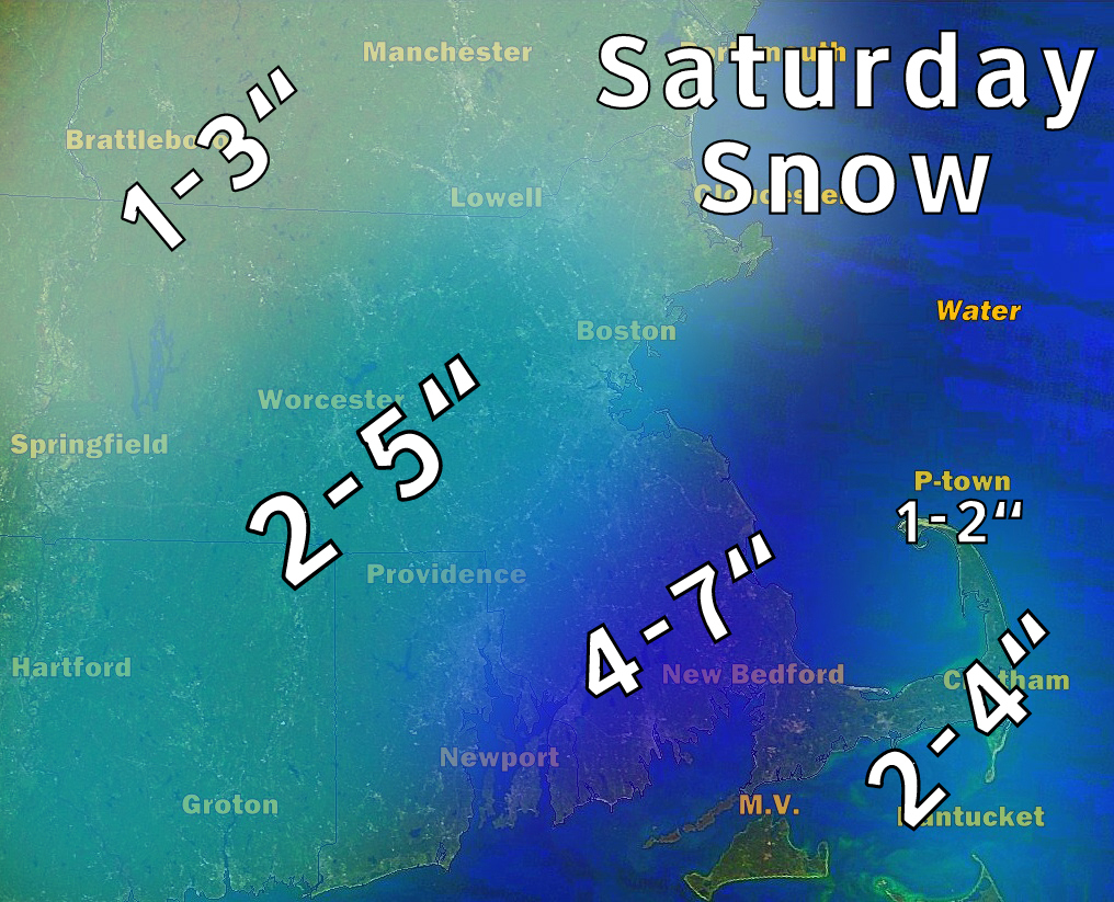
Snow will fall throughout much of northern New England tonight with some areas getting near a foot of snow. Boston will likely not see any accumulations and just a flurry or two early Saturday. (This is from an experimental model output for snowfall the HRRR)

Saturday will be very windy with wind gusts approaching 50 mph in Boston and up to 60mph on the Cape, where a High Wind Warning is in effect! Winds will be strongest from the West between 6AM and 1 PM. High temperatures will be in the mid 40s.


...HIGH WIND WARNING IN EFFECT FROM 4 AM TO 7 PM EST SATURDAY...

THE NATIONAL WEATHER SERVICE IN TAUNTON HAS ISSUED A HIGH WIND
WARNING...WHICH IS IN EFFECT FROM 4 AM TO 7 PM EST SATURDAY. THE
WIND ADVISORY IS NO LONGER IN EFFECT.

* LOCATIONS...NORTHEAST CONNECTICUT...NORTHERN AND CENTRAL RHODE
  ISLAND...MOST OF CENTRAL AND EASTERN MASSACHUSETTS.

* HAZARDS...STRONG GUSTY WINDS.

* WINDS...WEST 20 TO 30 MPH WITH GUSTS UP TO 55 MPH.

* TIMING...WINDS WILL BECOME WEST AND INCREASE TONIGHT. WINDS WILL
  CONTINUE SATURDAY WITH SPEEDS REACHING THEIR STRONGEST VALUES.
  WIND WILL DIMINISH SATURDAY EVENING.

* IMPACTS...STRONG GUSTY WINDS WILL EASILY BLOW ABOUT LIGHTER
  ITEMS SUCH AS TRASH CANS. THESE STRONG WINDS CAN ALSO KNOCK DOWN
  SMALL TREE LIMBS AND BRANCHES. WINDS THIS STRONG CAN ALSO MAKE
  DRIVING DIFFICULT...ESPECIALLY FOR HIGH PROFILE VEHICLES. USE
  EXTRA CAUTION.

PRECAUTIONARY/PREPAREDNESS ACTIONS...

A HIGH WIND WARNING IS ISSUED WHEN SUSTAINED WINDS OF 40 MPH ARE
EXPECTED FOR AT LEAST AN HOUR...WITH GUSTS OF 58 MPH OR GREATER
AT ANY TIME.  DAMAGE TO TREES...POWER LINES...AND PROPERTY ARE
POSSIBLE WITH WIND OF THIS MAGNITUDE. POWER OUTAGES ARE LIKELY.
TAKE ACTION NOW TO SECURE ANY LOOSE OUTDOOR OBJECTS.

Monday, February 20, 2012

2/20/12 Spring Like Weather to move in.. Big Storm (Rain) by Weeks end..

As I mentioned the other day. Some changes to the weather pattern are occurring this week.  The first, was a snow storm that swept through the North Carolina and Virginia yesterday, which is now south of New England. This storm will not bring any bad weather to New England, with the exception of some high clouds this morning.


Cool Canadian high pressure will build in for Monday and Tuesday allowing temperatures to climb to near 40 today and mid 40s by Tuesday.  The Low which is currently over Nebraska will actually track north east into southern Ontario and begin the strengthen. As this low will be north and west of New England, it will allow winds to bring in warmer air from the south, along with the chance of some scattered rain showers.


By Friday, the Low which is over the Pacific Ocean now will merge with the Low over Canada and strengthen into a potent storm, however, at this time the low appears as if it will move into Canada and allow for even warmer air to arrive by Friday where temperatures could top out into the lower 60's..  A strong cold front with perhaps thunderstorms are possible early Saturday.


Saturday, February 18, 2012

2/18/12 Slight rain/snow today. Major storm miss..

Something is happening with the weather... that is what you should know at this point! Yes this sounds vague, but a more active weather pattern appears to be shaping up as we head into March.  The first indication of this is seen on this mornings satellite image.  A large storm is developing over Texas and will bring severe weather and quite heavy rains to many Gulf coast states and even NC and SC. For parts of the mountains of VA and NC, up to 10" of snow could fall.  Also on this satellite image, a large storm over British Columbia and Washington will slowly track across the country and will influence our weather come Thursday into the weekend. It is yet to be seen if this low will split and then merge again along the coast next weekend. Yes, signs to a more active period.  As I look ahead into March with some of the models, they indicate that a more active storm track will take hold. Which could mean rains, snows along with some sun.


As for New England and Boston, sunshine will give way to an approaching weak area of low pressure now over the Great Lakes. 
Most of the light precipitation will fall as rain. There will likely be 2 batches of rain, the first arriving through Boston around 3 PM and the next arriving later after 7 PM.


As the evening goes on, and the air cools, some snow may mix in and fall across the area. In most places it will not stick, but in the higher elevations and in Southern NE (RI, CT) where the precipitation will be last to leave, 1/2 inch of snow may accumulate.


Friday, February 17, 2012

2/17/2012 And the search for snow continues...

If you haven't noticed.. there has been a snow drought around here.. Not only for Boston, but for much of the country as compared to normal.  

Some of you I am sure are happy to keep the shovels in the garage until next Winter.  There was discussion about a week ago and ending up today about a possible north east snow storm. That is not going to happen, but areas in the south are going to see a lot of rain and the first outbreak of severe weather for this early season.


This map shows the position of current storms in the heavy full color and tracks and positions in a faded color. Of note the low over the Pacific Ocean will likely bring rain next Friday. 
The low will bring in some high clouds during the day on Saturday, but rain should be limited and cold air is not seen for several days with temperatures remaining in the 40s.


Sunday, February 12, 2012

2/12/12 A cold February day... Finally

Yesterdays missed winter storm only brought some light flurries to the area as the storm intensified to far south and east of Southern New England to bring any accumulating snows. In fact, one would have to travel to far northern and eastern Maine to see any significant snows where up to 5" fall.
Satellite image of yesterdays storm intensifying over Nova Scotia. Too far east to influence much of our weather.
 The storm though did bring in behind it a much colder arctic air mass this morning, with temperatures falling rapidly overnight with much of New England now in a deep freeze.
From the WxBears weather station, the Arctic front passed coastal MA at 10 PM last night bringing a rapid drop in temperatures to a morning low of 14.9F.

The coldest air will remain in Northern New England and Maine where temperatures will struggle to get above Zero in some areas.
 For Sunday, a strong Northwest Wind will continue to bring allow for some CAA (Cold Air Advection) from Canada and will only bring temperatures up to the mid and upper 20's with wind chill values in the single digits and teens today.


A dry week ahead, except for an overnight passing shower as a warm front pushes through Tuesday night


Technical Stuff!!!

 A meteorologist will use many weather maps, but one of the most helpful is what is called the 500mb chart.  This map is produced by launching weather balloons at the same time across the world to get a picture of what the flow of the atmosphere is like.


The map is useful in showing many details, including "waves" of weather which are known as troughs and ridges. 
  • A trough, is a dip and signifies typically colder and negative (stormy) weather. Shown in a red line.   
  • A ridge is an area of typically warmer and good weather. Shown in a blue zigzag. 
The map above is showing a very large trough that has dug down into the east coast. This trough is allowing cold air from Canada to dip deep into the south as indicated by the blue arrows.  When a meteorologist sees such a trough, they can expect a storm to form ahead of it.  
  • In most cases in the weather, it is what happens above that influences the main surface weather.

The 500mb map typically lags the surface map, whereas on this map the trough is just about to enter New England, the surface storm has already developed.  And even though we are in the sunshine today, we must wait for the trough to either pass or modify in order to change the weather. 

 Think of this map as a roller coaster ride, and the blue arrows are cars full of cold air. The cars have just dived from Canada deep on the tracks into the South with cold air and are rounding the curve to climb back up. However, when they do this they are picking up moisture  and are full of energy to produce a storm.

Saturday, February 11, 2012

2/11/12 Where's the Snow??

Sometimes it is easy to jump on a weather bandwagon, sometimes you just don't see any other option and other times you realize that the science of meteorology is still growing.

The snow event that was to bring a few inches of snow to the Boston area is not going to happen as originally planned.

So, you want to know, what happened?  For starters, yes, there is a storm, a potent storm actually that you can see on the map below.
The storm is impressive looking on satellite images, but will be pushed out to sea instead of tracking closer up the coast. This is why the snow will be minimal in accumulation across New England today.
The snow will fall into warmer air as can be seen in the temperature reading in red. The Arctic cold front will usher in much colder air. Less than an inch of snow is now expected across New England
 Yesterday, it was thought that the storm would track just 20-30 miles north of its now present track, and allow a band to set up across New England and to fall into the colder air as snow and accumulate.


8 AM EST Temperatures (F)
The coldest air will stay in Northern VT, NH and Maine and will be trapped by the mountain ranges to our north, however the temperatures currently in the Ohio Valley will move in for Sunday, but will rebound by Monday.
Sunday Weather, The sun will return, it will be colder, with a gusty Northwest Wind creating a bitter wind chill.  
High in Boston on Sunday will be 28

Friday, February 10, 2012

2/10/12 Here comes winter, and the snow!

For one of the first times this winter, the weather pattern is showing what typically would be considered a winter storm pattern.

But first, a strong southerly flow ahead of a polar air mass will allow temperatures to surge to about 50 today.

On Saturday, what is known at the Polar Vortex, (an area of intense cold, will push south and east and drop temperatures 45-50 degrees by Sunday night from values today)  

So here is what is happening...  The main jet stream which flows a lot of the weather systems is dipping out of Montana over Texas and then moving up the East Coast.  The subtropical Jet stream, which is bringing in moisture from the Pacific Ocean over the Gulf of Mexico and up the east coast is very strong. A branch of the Jet Stream which is bringing in the polar air mass (Jet Stream P) is surging south and eastward.  These Jets or storm tracks are going to meet up along the east coast later today into tonight.  This will allow a weak storm over the Great Lakes to develop a coastal Nor'Easter off of the Carolinas (which right now is almost non-existant) and move up the coast. 

For 1 PM on Saturday, the Low pressure intensifies well south of New England at its closest approach. A strong high over Quebec will bring in the colder air while a Stronger high over Nebraska will usher in the colder air for 2/3 of the country.  weatheronline.co.uk


Snowfall amounts.  With the storm traveling far south a major snowstorm is not foreseen, but the heaviest snow will fall south of Boston from   Providence  - Brockton- . Lighter amounts will fall on the immediate coastline and just north/south of the Pike and in Boston expect up to 4 inches. Lesser amounts in NH and the Berkshires.    The cold air will be late in arriving on the extreme south shore and Cape and therefore the precipitation will begin as rain and continue for most of the storm. Therefore lesser amounts are forecast with a brief changeover later on the outer Cape.
 
Snow will start to fall late Friday night and into the early morning Saturday with the heaviest arriving at Sunrise until around 1 PM.
High temperatures for Saturday.. Cold air aloft will support snowfall except on the south coast at first. Temperatures will fall throughout the afternoon.
The snow will end by sunset on Saturday. After that, cold air (in the red and oranges and purples) will push into New England and down the East coast allowing for a very COLD windy day on Sunday and Sunday night!  Likely the coldest of this winter season.