My Personal Weather Station

Weather at Boston, Logan International Airport, MA - via NOAA's National Weather Service

Current Watches, Warnings and Advisories for Massachusetts Issued by the National Weather Service

Tuesday, April 24, 2012

4/24/12 The Aftermath of a Nor"Easter

An unsettled weather pattern will be with us over the next week.  With the passage of the Nor'Easter yesterday, residual clouds and showers will remain for the rest of the week along with some cooler air.

Our weather pattern can be seen on this mornings satellite image. As the low spins over Ontario, it will take several days to move east and will spin in a mix of sun and clouds over New England.


A simplified view of the weather for the next week.  Warm high pressure will keep the south, Mid Atlantic and Ohio Valley in early Summer warmth, while a small battle zone will set up between New England and the Mid Atlantic and on the north side, cooler weather will prevail as winds come in from Canada. Although it will not be COLD, highs will be normal, near 60 with the chance of passing showers, primarily along the south coast.
Much above normal temps are seen over the Ohio Valley. The Northeast remains near normal.
The week ahead will be tough to forecast when you can expect sunshine and when you can expect a rain shower.


Sunday, April 22, 2012

4/22/12 Major Storm to Move Up the Coast.

A late season nor'easter in set to cause some problems across the Northeast and into Appalachia overnight tonight and Monday.

For the Boston area, a cold front will struggle to push through Massachusetts and become stalled through the center of the state. This will be a focusing area as a developing low pressure over the Gulf of Mexico and Florida will move northward bringing heavy rain and winds.

It will be too warm in much of New England so expect heavy rains, however, further west into New York and PA, cold air will work in as another low over Iowa merges with the Gulf low and will create a damaging late season snowstorm, where over a foot of snow could fall .

Storm is similar in nature and structure to that of the Great Blizzard of 1993, with the exception of cold air in place due to time of year.
Impacts for the Boston Area:

  • Heavy Rain thru Monday afternoon up to 3-4 inches possible
  • Flooding of small streams and poor drainage areas likely
  • River flooding not expected due to dry winter and spring and drought conditions
  • Strong winds along the coast up to 40 mph
  • High surf possible.

Friday, April 20, 2012

4/20/12 Sunny, mild weather can be boring...

One of the biggest complaints from the general public about meteorologists is: "They get paid to lie and they are always wrong".  Well this week in point, I was wondering, how many of you thought, "The weather was horrible", "Or, those weathermen, all they said was sunshine and warm..(enter favorite curse)".   This is what tends to happen, when the weather is good and you have no interferences with any plans whether it be driving, a walk, or running a hot marathon, frankly it does not bother you.  It is what follows in my forecast that will then get you upset or make you a bit more weatherwise!

Enjoy the spring and summer like weather for the next 2 days, by Sunday, a potent Nor'Easter will track up the east coast to  bring wind and rain and cooler temperatures into the middle of next week.

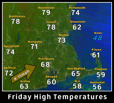
Today - Bright sunshine, southwest wind around 8-15 mph will keep the sea breeze at the immediate coastline.  Highs near 80 in the Merrimack Valley, Mid 70s Boston and upper 50s to 60 Cape and Islands.

South facing coastal areas and the cape and Islands will be the coolest including Cape Ann today.

High pressure today will bring in a warming Southwest wind.  A cold front and Low over the Gulf will be our weather late on Saturday and into next week.


On Saturday - a mix of sun and clouds along with some fog will start the day as a cold front approaches but never reaches eastern New England. A south wind will still keep temperatures mild into the 70s. It should remain mostly dry until later afternoon.

The front is seen stretching from the Gulf of St Lawrence to Georgia and  low developing in the Gulf of Mexico on this forecast rain image.

Late Saturday into Monday - The cold front gets hung up over western New England as a major storm develops in the Gulf of Mexico and this storm helps push the front back to the west and will also be a focal point for very heavy rain with 1-3" of rain falling.


By Monday, the low and the front merge over New England to bring heavy rain and winds over New England on Monday. (A potent snowstorm could set up in the higher elevations of New York and even PA)


Tuesday, April 17, 2012

Subtropical Cyclone could be forming in Atlantic...

As mentioned last week, an area of low pressure east of Bermuda is becoming curiously subtropical in looks as it continues to slowly spin westward over the North Atlantic Ocean.

The storm would move near Bermuda, then be picked up by a cold front and pushed back out to sea come Thursday.


A close up of the swirl of the 999mb storm, if thunderstorms start forming near the center or around the bands of this storm, a subtropical cyclone could form.


Monday, April 16, 2012

4/16/12 A record HOT Patriots Day and Marathon Day!

Record heat will invade much of Southern New England (away from the south coasts) today with quite a few areas reaching the lower 90s as a southwest wind brings in the heat.

90s will be seen in the Merrimack Valley of NH and MA today. Elsewhere upper 80s are likely across much of the state.  South facing coastal areas and the Cape and Islands will be coolest today. 

Keep in mind the ocean water temperatures are in the mid to upper 40s!! 

UV readings will also be high today 6-7, which if outside without any sunscreen can produce a sunburn.

Fire danger is extremely high today, please use extreme caution if bbq'ing, smoking etc.  Any spark could ignite a brush fire as the ground is extremely dry and the dry conditions today will help fuel any fires.


The Marathon will be plagued with hot temperatures. I am sure if you are running you are aware of what the heat will do. If you are spectating, keep in mind the high temperatures can also take its toll on you with dehydration, sunburn and overheating. Please take care.


The cold front to the west will push through overnight tonight, but move well north of us, so temperatures will only gradually cool over the next few days.

Saturday, April 14, 2012

4/14/12 Summer Heat Returns Again

Once again, a major warm up will be expected across Boston this weekend and on the Patriots Day Holiday on Monday, which does not bode well for Marathon Runners.  Expect summer like heat to be in place across much of southern New England until Wednesday.

For today, Saturday,  the last of the cool air will be pushed out and we can expect most areas to rise into the lower 70s.

A south wind will keep south coastal areas cooler as the wind blows in off of the ocean.

The battle between summer and spring will play out along a cold front slowly approaching from the midwest into early next week, but most of the active weather and colder air will get pushed north and a return to normal temperatures return by mid week.

A chance for an evening Thunderstorm is possible each evening and overnight.

Wednesday, April 11, 2012

Tropical Update - Possible Alberto to form Next Week, no threat to land

A cold front that will push off the US coast will stall over the warm waters of the Atlantic early next week with a wave of low pressure forming along it, roughly 1100 miles east of Florida.  This low will sit and could take on tropical or subtropical characteristics, with winds around 55 mph.

No threat to any land is expected.  If it gets above 39 mph, it would be named Alberto. (if it gains enough tropical characteristics, which the models do hint at.)

Model satellite image showing what looks to be a well defined semi-tropical low 1100 miles east of Florida early next week.
Model Surface map and precipitation, showing banding features, which is typical of a semi-tropical system.
In the month of April, two other sub tropical cyclones have formed in 1992 and in 2002.