My Personal Weather Station

Weather at Boston, Logan International Airport, MA - via NOAA's National Weather Service

Current Watches, Warnings and Advisories for Massachusetts Issued by the National Weather Service

Saturday, November 3, 2012

11/3/12 Potential Severe Nor'Easter to impact Sandy areas

A significant Nor'easter is shaping up for later mid week.

Right now it is too early to say the direct impacts, here are some details.

  • Significant Snow in New England
  • Light Snow in Boston, NYC
  • Coastal Flooding possible
  • Winds - Gale to Storm force possible  (30-60mph)
The weather map for 7 PM Wednesday showing a strong storm south of Cape Cod.  Colors on this map indicate wind speed. A strong North East wind will impact New England with high gusts and strong waves prompting some coastal flooding.

SNOWFALL

The first significant snow will fall across the higher terrain of New England with over a foot possible in the Berkshires.

I would not yet be confident in an exact forecast, but take with this the following:

  • Purple -  general coating to 3"
  • Blues - 3-6"
  • Oranges - 6-12"
  • Deep red - Over a foot"

Also, Sunday night will feature a widespread freeze across ALL the Boston area, Expect any remaining outside plants to freeze and if you have yet to do so, prepare for winter now.

Friday, October 26, 2012

10/26/12 Please take serious read about Sandy

I know you want to know where Sandy is going and what will happen for you?

There are 2 main scenarios as to where Sandy is going to go.

2.  Sandy makes a very hard left toward the NJ, Delmarva coast. ( discussed later)

1.  Sandy still turns left, but gets a bit further north and tracks WEST along the Southern
     New England coast.


Lets take a look at # 1.   (for my MA friends)

This idea scares me so much.  Most everyone reading this will not even be able to comprehend what could happen in this type of situation. 


Hurricane Sandy in this scenario runs up the coast but come back west toward the SE Massachusetts coastline by 8 AM Tuesday morning. 

Sandy then either skirts the south coast into Long Island or NYC. What is frightening is that in all of history, most hurricanes are coming at New England from the south and moving Northeast.  Sandy will NOT be doing this

Sandy will be coming at New England from the North West.  The worst part of Sandy will be her right front quadrant relative to storm motion. Wind will pile waves

For Boston tho:

  • Possibly 6 hours + of hurricane force winds ( Green area)
  • Coastal Storm Surge 3-6 feet. Cat 1 or 2.
  • Waves 30+feet 
  • Rainfall 

If you are concerned about where you live, check out the maps at this link http://www.iwr.usace.army.mil/nhp/HESfacts.cfml?pgid=109

each town, or region is mapped out to show you the effects of storm surge in your area. Prepare now!!  

Winds -  the scariest situation I am seeing is both storm surge and WIND.   One of the computer models is suggesting that 115 mph wind speeds will be just above the surface (indicated in the browns on the map below)  Since Sandy will not be in a true tropical state, these winds could mix down to the surface at any given time.   Note too the wind field with Sandy it HUGE!   Gales extend from South Carolina to Nova Scotia and back to Ohio and Ontario!


If you want to see what Sandy could be capable of doing, watch this video from 1938.

http://www.youtube.com/watch?v=7b21g-5YBLs

Follow these tips to prepare yourself.

http://www.mass.gov/eopss/agencies/mema/mema-offers-tips-as-hurricane-sandy-approaches.html


Monday, October 22, 2012

10/22/12 Halloween Storm Sandy

There is some hype going on about the potential for a major storm event to take place beginning later this week.

Right now, an area of low pressure is developing over the Caribbean Sea.


The low will be slow to move northward and will be in the Bahama's , later this weekend. If named it will be Sandy.

For New England - the weekend looks sunny and mild.

Then next Monday - all of the east coast from North Carolina to New England needs to prepare for a late season, prolonged deluge storm. 

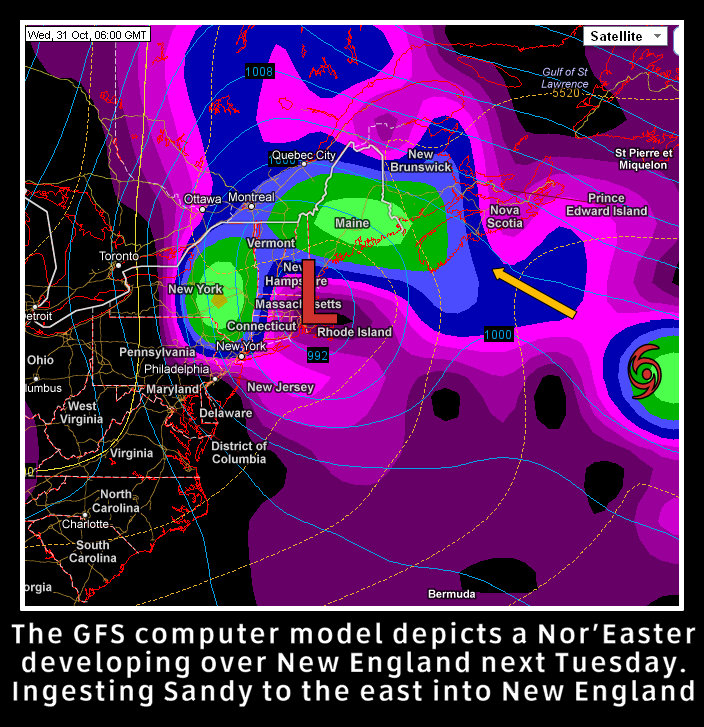
Interestingly, the GFS ( a computer model) has a Grace/Perfect Storm set up this morning. With a Nor'easter developing over New England, ingesting the moisture from what could be Sandy.

Although it looks not as mennacing as what will follow, the models keep this low/Sandy spinning off the New England coast for 6 days. This could bring a lot of wind, erosion and more.


A more intense situation lies in several other model outputs showing Sandy tracking up the east Coast.  The Nor'Easter still develops, but instead, keeps Sandy as a separate entity and merges the two into a powerful storm over the mid Atlantic and North east next Tuesday into the week. 


There are some discussing a similar weather pattern setting up to that of 1954 and the infamous Hurricane Hazel.  The initial pattern looks similar, but in this case, Sandy then could get trapped in or just off the Northeast.


Monday, September 3, 2012

9/3/12 - Tropical Impacts for New England - Next Week.

1st -  Let me apologize for being absent for much of the summer. I have been embarking on a new career path that has taken up a lot of my time. However, I still would like to present important weather information seems appropriate to you, however, at this time a daily forecast cannot be made. When the business aspect takes off, then I hope to be able to do a little bit of both!

2nd - The time has come to update you a possible impact from Tropical Cyclone Leslie.

An interesting meteorological pattern may be setting up, one that we saw in 1989. 

Hurricane Leslie is expected to pass near Bermuda later this week. Typically this track means clear sailing for much of the United States coastline and only a threat to Atlantic Canada.

However, some changes are occurring that are having some meteorologists rethink the eventual track of Leslie.

A trough of low pressure that was forecast to develop and pick up and kick Leslie out to sea, will appear to be actually closing off over the Southeast US.   This will act, instead of a kicker, as a pull system and pull Leslie closer to the US Coast.

As was the case with hurricane Hugo in 1989, the track, not seen brought the hurricane in on a direct path into SC.    This will not be a Hugo, however, what I am seeing is a storm that could be pulled closer to the US coast as it passes by Bermuda, an unusual pattern.  This has been coming to light throughout the day today.  

The worst case scenario now could be that Leslie tracks very close to the Outer Cape (Cod) on Tuesday of next week as a very strong hurricane. Some models are bringing this to a Category 4 near Bermuda.   The track could change of course, and I will keep you posted on any changes!   The least worrisome at this moment will still possibly bring some windy conditions to eastern New England, high seas and a possible shower closest to the coast.


Model Weather Map for Tuesday, Sept 11, 2012..  Leslie is very close to Cape Cod in a worst case scenario.  This may change, but it is something to watch.

Friday, June 29, 2012

6/29/12 Hot weather returns

A heat wave is expected to invade the Boston area this weekend (3 or more days above 90).

The massive heat that has been building in the Rockies and south will move in today and stay with us until Sunday, when a bit of a cool down back into the 80s returns for the holiday week.

It will be coolest along the coastal areas and south facing beaches today.
For today, Friday, a few scattered showers and thunderstorms will move through during the morning hours, then reform later in the day. Expect mid 90s in most places, except upper 80s at the beaches with upper 70s to lower 80s on the Cape. Dew point levels will be dropping today, so it will not feel as humid today or tonight, but will rise over the weekend.

Our heat today is being transported in around a very HOT high pressure to the south. The flow for New England will be mostly west though so the extreme heat remains south.
Scattered Thunderstorms are possible each day, but no areas of organized rain is expected.

Monday, June 25, 2012

6/25/12 Cold then back to summer heat. Rain today!

A strong cold front is pushing its way across New England this morning that will bring heavy rains and thunderstorms across the region as the morning progresses.

Forecast radar image for 11 AM this morning, with one heavy band of showers and thunderstorms moving through Eastern MA.

As the front moves through, over an inch of rain could fall from the storms.  An area of low pressure will form just off the New England coast and will keep the rain from moving too far offshore and keep the clouds around more much of the coastal areas.

Tuesday looks to be a very cool and damp day with a few breaks of sun from time to time especially in southern locations.

Temperatures on Tuesday will be 10-12 degrees cooler than normal.  As the area of low pressure off the coast spins, it will allow for clouds to rotate around it and make for a cloudy day except for the southern parts of New England.

The cool is short lived once again and heat will return for the weekend.

Heat will build across the south east and move into New England for the weekend with temperatures getting into the upper 80s and lower 90s.   It will once again be short lived as a cold front will push through late Sunday into Monday.   Debby will be a slow mover off the FL coast.


Tuesday, June 19, 2012

6/19/12 Get Your A/C's - Summer is coming!!

Yes!  Summer will arrive tomorrow and the weather will also reflect summertime heat. The cool weather of the past few days will be pushed away as heat and humidity return for a full blast of HOT HOT HOT!!
How it will feel tomorrow afternoon


The heat will only last until Friday, as a another shot of cooler air moves in for the weekend.

However, it will remain extremely humid Wednesday and Thursday night with temperatures only falling into the upper 70s and it will be extremely sticky!   If you need an A/C  get it today before the stores have a mad rush on them!