Unsettled weather is in store for New England over the next week. We will experience a weak trough developing over the east coast. This will not be a week of constant rain, but daily showers can be expected until Thursday.
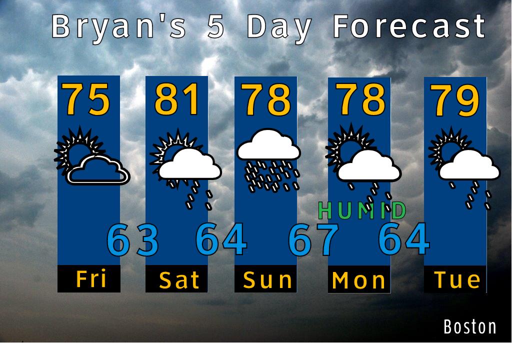
Today - A cool flow remains in off the ocean, and will keep temperatures low and humidity low as well. A great day overall.
Saturday - A warm front approaches with an increase in humidity will be noticed. Scattered showers arrive around 5 PM and last into the over night.
Sunday - Rain in the morning hours will give way to spotty showers by mid afternoon.
Monday and Tuesday - There is the chance for an afternoon shower each day, heavy rain is not expected, but there will be a mix of sun, clouds and rain.
Wednesday - A rainy day overall.
Ptown Forecast -
Rain tends to hold off on the Cape until Sunday afternoon. A few High clouds are around on Saturday.
My Personal Weather Station
Weather at Boston, Logan International Airport, MA - via NOAA's National Weather Service
Current Watches, Warnings and Advisories for Massachusetts Issued by the National Weather Service
- Wind Advisory issued March 16 at 2:53PM EDT until March 16 at 10:00PM EDT by NWS Albany NY
- Special Weather Statement issued March 11 at 5:36AM EDT by NWS Albany NY
- Special Weather Statement issued March 10 at 5:30PM EDT by NWS Albany NY
- Special Weather Statement issued March 10 at 5:26PM EDT by NWS Boston/Norton MA
- Cold Weather Advisory issued March 1 at 2:25PM EST until March 2 at 11:00AM EST by NWS Albany NY
Subscribe to:
Post Comments (Atom)
No comments:
Post a Comment