My Personal Weather Station

Weather at Boston, Logan International Airport, MA - via NOAA's National Weather Service

Current Watches, Warnings and Advisories for Massachusetts Issued by the National Weather Service

Friday, May 27, 2011

5/27/11 Here's to Summer!

Humid warm weather returns. Scattered thunderstorms possible late in the afternoon today. Some severe north and west of Boston.


Today we can expect a lot of sun, fog will burn off by mid morning along the coast and temperatures rise into the lower 80's. Mid 80's in some areas.


Some severe weather, likely in the form of small hail and strong winds is expected throughout much of New England today, with the exception from about 495 Eastward.  However a stray shower could produce heavy rains and gusty winds in any area.

Green areas are where thunderstorms are expected. Yellow Shading is where there is a slight chance of a severe thunderstorm. (Winds >58mph, small hail, possible tornado)

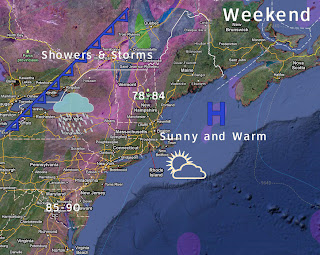
Expect it to be slightly cooler on Saturday, especially along the coast and the northshore, then warming up again on Sunday with warmer temps on Monday and Tuesday. Could approach 90 in some areas.

Thursday, May 26, 2011

5/26/11 Summer Type Weather to Return

Thursdays Weather - Most areas will see 80.
We have waited all year for this type of weather.  We have entered a weather pattern where a frontal boundary will stall pretty much along the Canadian/US border from Maine to the Great Lakes. Much of the active weather will be focused along this line, well to our north and west.
High Pressure moves off the coast allowing for a south wind to bring in warmer temperatures and a bit more humid throughout the weekend. Friday and Monday look to be the warmest 2 days.


The seabreeze should be confined primarily to the immediate coast today and Friday.


You will notice that the humidity will increase some, but will not oppressive. Dewpoints will be around 60 for much of the weekend after today.

The only cool spots will be directly along the coast and the Islands and then Nantucket will be the only spot to remain in the upper 60s to near 70 all weekend.

Rain will be confined to northern New England, for Friday and Saturday with a few showers sneaking into the Berkshires early Saturday morning, but otherwise it is looking dry.

With a summertime pattern setting up, there is the chance for a spot afternoon shower or thunderstorm.

Wednesday, May 25, 2011

5/25/11 Warmer Weather returns

A Pleasant Dry Day today - Cooler at the coast.
A cold front pushed through the area overnight ushering in cooler drier air from Canada. Clouds from Rockport to Portsmouth will diminish during the morning hours and only a few passing clouds can be expected during the day today.

A sea breeze will set up during the afternoon hours keeping temperatures in the upper 60's along the coast with mid 70's inland.

Today's Forecast - Cooler at the Coast

Thursday looks to be a bit warmer than today with lots of SUN!


The Memorial Day Weekend forecast is slightly tricky as a cold front will stall out over Northern New England.  Expect clouds and rain over Northern Vermont and New Hampshire, however high pressure should stay in control over much of MA, the Boston area and the Cape allowing temperatures to rise into the 80's.  A bit cooler at the coast.


A week cold front will get hung up over the St. Lawrence area, and weaken as it pushes southward during the day on Sunday. High pressure will keep southern New England dry and warm, Clouds and showers will be more numerous across far Northern New England.

Tuesday, May 24, 2011

NorthshoreThunderstorms

A line of showers and thunderstorms will be in Beverley, Salem, Gloucester and Rockport between 830 -9 PM

Boston Hits 80 Degrees!

Boston (KBOS) hit 80 degrees today for the first time this season.


Last year we had already reached 80 degrees 6 times by this time.

5/24/11 Whats that I feel? Warmth and some humidity...

Morning clouds will thin out some during the day today bringing us peaks of sunshine, although it will not be a pure blue sky all the day long.  Temperatures should reach into the lower 80's especially North and West of Boston.   South and Cape wise, a south wind will keep temperatures in the 70's.  Depending on how much sun shine will determine the actual high, so if Boston can get sunny for a few hours between 10-2, 80 is possible. Yes the temperatures are slightly lower than yesterdays forecast due to more cloud cover from dying thunderstorms over PA and NY.

Tuesday's High


You may notice today that it is sticky, dewpoints are climbing into the mid 60s for today. So the air will feel summer like, that is for sure.

A cold front will push through the area during the late afternoon hours sparking off some showers and thunderstorms.  There is the slight risk for a severe thunderstorm to pop up, especially north and west of Boston where the air will heat up. At any case the airmass will be moist and heavy rainfall is likely.

Bright sun returns tomorrow with cooler temps and drier air. Temps should be in the lower to mid 70's inland and upper 60s coast, lower 60's on the Cape.

Monday, May 23, 2011

5/23/11 You want summer?... you'll get it.. for a day at least!

As you may be hearing about last nights severe weather in Missouri and Minnesota , some of that weather will reach us in our forecast.  But first..
Monday's Forecast temps


Morning rain showers will be pushing off the coast in the next few hours ahead of an approaching warm front. Some clouds linger behind so clearing will be sparse throughout the day. Temperatures, despite the warm front passage will only get into the middle 60's today. The remainder of the day should remain dry.

A batch of showers and thunderstorms over NY/PA will fire up during the afternoon hours today and slowly propagate eastward during the overnight hours.  By the time they reach us here they should be dying down to just a passing shower perhaps a rumble of thunder and yet again be out of the picture by 8-9 AM on Tuesday.

Tuesday, a southwest wind and sunshine will push temperatures to around 80 for much of the area with the exception of the the Cape and Providence area where the temps will reach the mid 70's due to a wind off of the Atlantic (from the South)

Tuesday's forecast- A nice stretch of mid 80s from Manchester, NH - Lawrence to Hartford. (This area could also see the most intense storms later tomorrow)

We will be in a warm air mass as a cold front approaches and although the set-up will not be the same as it was over the plains last night,  there will be the chance for some strong to severe storms late tomorrow afternoon into tomorrow night with small hail and strong winds possible.  Places that reach 80 tomorrow will likely have the best shot of seeing the chance for a line of thunderstorm to pass ahead of a cold front.

Wednesday, cooler air moves in again, but should be dry. The front slows down so areas on the Cape may be stuck in the clouds more.

Update Tuesday on Weekend Weather.

Sunday, May 22, 2011

5/22/11 Summer time weather to visit...

Saturday was one of those interesting weather days when so much happen more on the local scale than on the large scale.

Saturday afternoon Vis Sattelite image, tells a good story.

As for today, well the backdoor cold front pushed through much of New England over night. Not too much in the way of rain in eastern MA, but some thunderstorms popped up westward.

Today should be a dry day with some morning low clouds. The sun will work to burn that off and provide us with some sunshine, however it will be noticeably cooler today with the exception of Western Mass, where it will reach 70.  Some areas out on the Cape will struggle to get out of the lower 50's today and may remain in the clouds for most of the day.


High clouds associated with an approaching warm front (the backdoor front gets pushed back in a normal direction) and will bring in a change of airmass and wind direction.

Since last Monday our wind direction has been primarily out of the east, the winds will now shift to the south and southwest.  A warming wind.

Monday expect some early morning scattered showers as the front pushes through. Temperatures will be coolest along the southshore, RI and Cape, warmer to the north and west. Scattered thunderstorms are possible throughout much of the area later in the day, some may produce some strong winds and hail.

Tuesday a perfect set up for some much needed warmth, many areas will reach into the lower 80's. Boston depending on how much sun and exact wind direction and timing of a sea breeze will struggle to reach the 80 mark, but may top out at 79! A cold front approaches during the late afternoon and early evening which could again trigger some thunderstorms.

Of note this week in the weather pattern, the systems are moving along very nicely and are not stuck like they were last week, so we can expect a quick round of showers here or there, but intermixed with sun and clouds, so your days will not be a wash out and you can work on getting that tan!


Memorial Day Weekend Outlook: Boston Area

Friday-  Increasing clouds, scattered T-storms 72-78
Saturday -  Morning clouds then sunny 67-74 cooler at the coast
Sunday -  Mostly sunny  68-75  cooler at the coast

Monday - High clouds   Cape low to mid 60's
                                  Portland-Boston- Providence 68-73
                                  Bangor-Manchester-Hartford  70-75
                                  CT River Valley - NYC - 73-78