My Personal Weather Station

Weather at Boston, Logan International Airport, MA - via NOAA's National Weather Service

Current Watches, Warnings and Advisories for Massachusetts Issued by the National Weather Service

Saturday, May 21, 2011

5/21/11 A little bit of everything.

A lot of moisture is around.  The ground is nicely soaked, (no droughts at least).  All of this moisture is leading to some foggy conditions in the morning hours and this should continue for the next several days. Depending on cloud cover where you are located the fog could hold on for a bit of the morning hours.

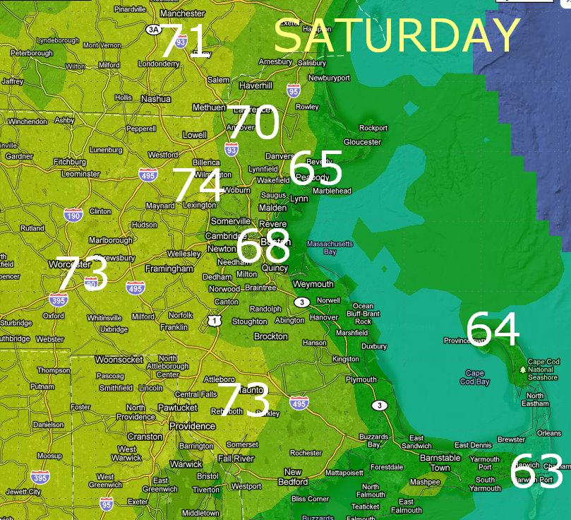
Today's weather really is all about location. The closer to the ocean you are, the cooler it will be. Some locations like Gloucester/Rockport & P-town will stay in the mid to upper 50's.   City of Boston lower to mid 60's and inland Worcester & 495 around 70 and mid 70s Springfield way.   Sunshine will also play a role. If the sun comes out and burns off the fog before it builds the clouds temps could warm a bit more along the coastal areas. 

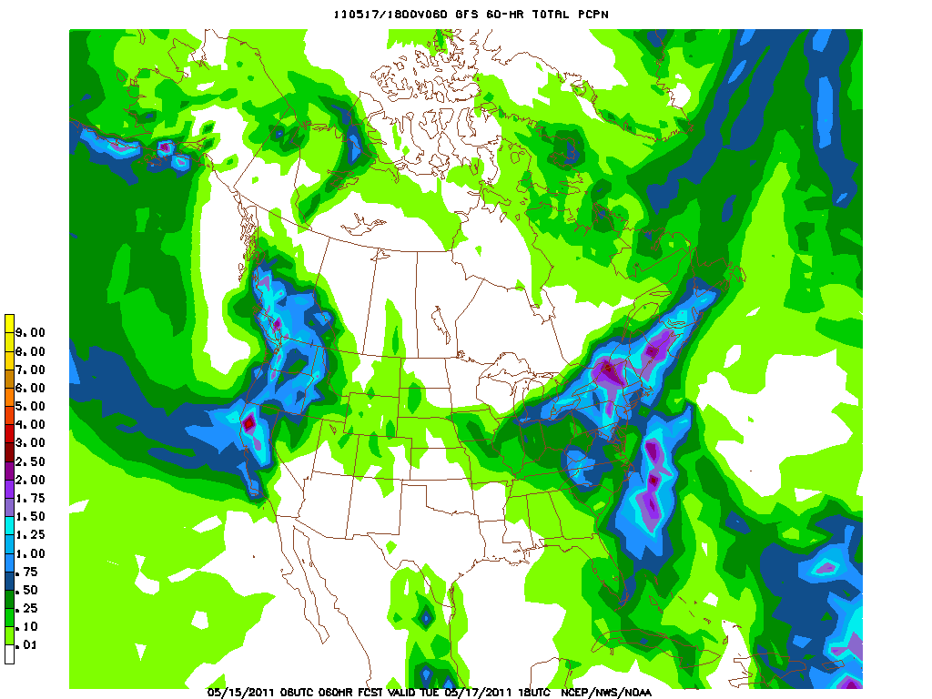
Rainfall today looks to be limited more to southern RI, CT. The Berkshires and Green Mountains in VT.  Then northern VT NH and Maine associated with a backdoor cold front. Still cannot rule out a thunderstorm or shower, especially where the temps warm. The cooler air along the coast should limit thunderstorm development.


Sunday - You get some sunshine!!!  but cooler temperatures again especially along the coast. Take todays weather and subtract 5-8 degrees.  

Monday there is the chance for some morning showers, but otherwise not a bad day then Tuesday is the winner with a perfect set up of winds were everyone should be in the 80's. Would not be surprised to see some mid 80's in some areas come Tuesday.


Weather word of the day:
Backdoor coldfront -  a typical weather pattern goes from west to east at our lattitude. When a front moves in the opposite direction, from Northeast to Southwest (i.e from Maine to say CT) this is a backdoor cold front.

Friday, May 20, 2011

5/20 Here's to the Sun!!

Amazing what just a few minutes of sunshine can do.  If you saw some peaks of sun yesterday, you know that it warmed up nicely and the moisture in the ground and on the roads began to dry up.  This morning will start out foggy again, but with drier air moving in and no rain in the near view it should burn off and provide us with some breaks in the cloud cover.  The airmass aloft is still quite cold as the low remains over NY/PA today and the sun will create some instability and I cannot rule out a shower or thunderstorm today, but it looks more concentrated out west of Boston. 

Friday Forecast:  Morning fog, burns off to partly cloudy skies, a possible shower of thunderstorm late. High of 67.

Saturday looks to be a decent day. It will start out with some sun in the morning with building clouds after 12pm with the possibility of a scattered shower or thunderstorm, clearing by late afternoon and early evening. Cooler at the coast.  Mid 70's inland, mid 60's coast.

Saturday's High Temperatures

Sunday  a backdoor cold front  pushes into the area and expect a sunny day but temperatures about 7-10 degrees colder than Saturday.

Luckily it is short lived and warmer air returns with more sun for the week.  There is the chance for a passing shower on Monday, but with temperatures around 70 going up to near 80 on Tuesday and Wednesday, it will feel more like May, than early April.

P-town forecast:    Friday  mix of sun and clouds a chance of a shower Low of 50
                               Saturday mix of Sun and clouds chance of a shower High of 64
                               Sunday  much cooler, possible fog mixed with sun High of 55
                               Water temperature:  49

Thursday, May 19, 2011

5/19/11 ...with special guest start - The Sun!

Ok, you may be saying, yeah right when I see it, I will believe it.

Don't let the graphic fool you! It is not a total washout.
 Looking at the NWS page for Boston, you would think that it is going be dreary and rainy all weekend. Not the case.  Lets break it down day by day for you.


Today: Today is really the final day of the mess.  The upper low is finally moving on up and overhead today.  Some areas will see some breaks in the clouds and some possible sunshine, so it is not a total washout. There is the chance for a spot thunderstorm.

Breaks in the cloud cover will allow the sun to poke through, esp over the Cape and Islands


Friday:  Location is key here for the forecast. Right along the coast, it will be cool, inland warmer. Worcester should reach 70, Boston mid 60s. If the sun makes an appearance for a while longer then the temperatures could get slightly higher, however more sun will produce more clouds. There is the chance for some severe storms more so over central MA and CT, but some storms could work their way to the Boston area.  A weak onshore flow will keep it cooler right along the coast.

Saturday:  Not too  bad, similar to Friday with possible pop up storms. The only negative thing will be a backdoor cold front pushing in from Maine during the afternoon.  The morning and early afternoon should be nice with increasing clouds. A sea breeze will also develop so cooler along the coast again. Expect 60s along the coast to near 70 inland.

Sunday: Drier air, but slightly cooler air moves in, but the presance of sunshine will make it all the better. Highs will be in the 60s

A much drier and warmer period lies ahead. Look to see 70's to near 80 and more sun next week.

Wednesday, May 18, 2011

5/18/11 Do I sound like a broken record?

Not much has changed folks in the weather department this week.  The pesky upper low ( a cold pool of air aloft) is still hanging out over the east coast, slowly moving bringing in colder air. There was even snow in the mountains of North Carolina overnight!

As for New England and Boston, we should be a few degrees warmer today than the past few and everyday just inches a bit warmer. So expect lower 50's today and mid 50's tomorrow. The chance for heavier showers do exist today however.

(a funky map -bad render)  Major trough in the east bringing in colder air from Canada.  


Cannot rule out a scattered rumble of thunder today or tomorrow.  Finally come Friday the low begins to move out, but cold air aloft will allow for clouds to build during the daylight hours, but the chance to see breaks of sunshine are definitely possible and even moreso on Saturday, still with the chance of showers.  Temperatures rise gradually into the 60's to near 70 by Saturday. A tad cooler on the coast on Sunday with 70's for Monday and Tuesday.

Tuesday, May 17, 2011

5/17/11 PM Update

Scattered rain showers will rotate in from the southeast during the evening hours, most of the heavy rain will remain over RI and CT, but an occasional heavy downpour is possible in some areas. Temperatures will remain near 50. Overnight

Heavier showers and a thunderstorm are possible over southern New England tonight. Lighter showers will come through the Cape and Boston throughout the evening, 

5/17/11 Rain rain go away...

Not much new to say today folks. The rain is with us at least until Friday and finally clearing out Saturday with Sunday looking to be a great day.  Temperatures will be cool for another day or so, but as the pesky low begins to weaken temperatures should moderate back into the lower 60's. 
Rain and some thunderstorms will form along the warm front over NY/NJ today and start to push east into CT and Western MA. These showers should hold off in the Boston area, but some could reach the area by late afternoon.

The low will be slow to move, but come Friday much of the rain will push away as an area of high pressure from Canada will move in. However with such an unstable airmass in place, a spot shower on Friday and Saturday cannot be ruled out, but it will not be a washout.  Another key factor too will be the winds. The have been and will be coming in from the east off the ocean, by Friday they shift to the south and west, (typically a drying warming wind) 

Weekend Forecast

Friday - High 65  Chance of a shower mostly cloudy
Saturday - High 67-72  slight chance of a pop up shower
Sunday - High 74-79  Partly to mostly sunny

Monday, May 16, 2011

5/16/11 Rainy Days and Mondays....

When a picture can say it all.  That nice donut of a spin over Alabama is what is causing our "wonderful" weather.   This spin is rotating counterclockwise. See all the white (moisture) over the east coast of the Atlantic that is all moving northward around that low right into New England.  This is our moisture feed that will not move much over the upcoming week, however the beginning of the week looks worse than the later part of this week, however clouds and rain will be with us everyday I am affraid.

There is a front currently just south of New England that is holding a warmer and more humid airmass away from us. This front really has nowhere to go and we be a focusing mechanism for continued rain showers on and off.  There is the possibility of some these storms to overide the front, especially on Tue and Wed and a spot thunderstorm is not out of the question.  With a pattern like this too there is some dry air just to our south and west (the darker area on the map).  Some of this could work into parts of New England at anytime and give a momentary break in the cloud cover, so some may see brightening skies or a peak of sun, but sadly it will be short lived.

Strong east winds will set up off of the ocean as well enhancing cloud cover, cool temperatures and wave action.  Temps will be below normal for most of the week. With highs in the upper 50's to lower 60's.  Friday looks to be the best bet for a break, especially coming in from the north through Vermont. 

If you have weekend plans, Saturday currently looks to be a decent day with a mix of sun and clouds and warmer with highs in the lower to mid 70's, cooler on the Cape.


Sunday, May 15, 2011

5/15/11... Umm can someone clear the atmospheric traffic jam?

If you like clouds and rain, this is your type of week!   An area of low pressure will stall out over the Carolinas at least until late Thursday this week. We are in a blocking pattern. Think of it as a car on the highway that is broke down. In order to get around it you have to take a long detour, or just wait it out until it moves. That is what the atmosphere is doing now.  The low is stuck and the weather has to take the long way to get around just to move.

Two big blocks in the east and the west will keep our weather unsettled for most of the week.
 
 This area of low pressure will direct rain around it counter clockwise into New England. A weak frontal area will set up over New England as the boundary between the drier air (High) from Canada to the moist air (Low) over the south. This boundary will act as a lifting mechanism and whenever you get lift in the atmosphere, you get clouds and rainfall. This boundary will shift back and forth as the steering currents remain stalled out. So expect areas of rain to be scattered but persistent through Thursday. The mountains will also play a roll in this event creating locally heavy areas of precipitation.

Precipitation until Tuesday. The heaviest will be over the Adirondacks, Green and White Mtns and Maine. Still an inch of rain is possible in the lighter blue shade.