My Personal Weather Station

Weather at Boston, Logan International Airport, MA - via NOAA's National Weather Service

Current Watches, Warnings and Advisories for Massachusetts Issued by the National Weather Service

Saturday, February 18, 2012

2/18/12 Slight rain/snow today. Major storm miss..

Something is happening with the weather... that is what you should know at this point! Yes this sounds vague, but a more active weather pattern appears to be shaping up as we head into March.  The first indication of this is seen on this mornings satellite image.  A large storm is developing over Texas and will bring severe weather and quite heavy rains to many Gulf coast states and even NC and SC. For parts of the mountains of VA and NC, up to 10" of snow could fall.  Also on this satellite image, a large storm over British Columbia and Washington will slowly track across the country and will influence our weather come Thursday into the weekend. It is yet to be seen if this low will split and then merge again along the coast next weekend. Yes, signs to a more active period.  As I look ahead into March with some of the models, they indicate that a more active storm track will take hold. Which could mean rains, snows along with some sun.


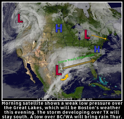
As for New England and Boston, sunshine will give way to an approaching weak area of low pressure now over the Great Lakes. 
Most of the light precipitation will fall as rain. There will likely be 2 batches of rain, the first arriving through Boston around 3 PM and the next arriving later after 7 PM.


As the evening goes on, and the air cools, some snow may mix in and fall across the area. In most places it will not stick, but in the higher elevations and in Southern NE (RI, CT) where the precipitation will be last to leave, 1/2 inch of snow may accumulate.


Friday, February 17, 2012

2/17/2012 And the search for snow continues...

If you haven't noticed.. there has been a snow drought around here.. Not only for Boston, but for much of the country as compared to normal.  

Some of you I am sure are happy to keep the shovels in the garage until next Winter.  There was discussion about a week ago and ending up today about a possible north east snow storm. That is not going to happen, but areas in the south are going to see a lot of rain and the first outbreak of severe weather for this early season.


This map shows the position of current storms in the heavy full color and tracks and positions in a faded color. Of note the low over the Pacific Ocean will likely bring rain next Friday. 
The low will bring in some high clouds during the day on Saturday, but rain should be limited and cold air is not seen for several days with temperatures remaining in the 40s.


Sunday, February 12, 2012

2/12/12 A cold February day... Finally

Yesterdays missed winter storm only brought some light flurries to the area as the storm intensified to far south and east of Southern New England to bring any accumulating snows. In fact, one would have to travel to far northern and eastern Maine to see any significant snows where up to 5" fall.
Satellite image of yesterdays storm intensifying over Nova Scotia. Too far east to influence much of our weather.
 The storm though did bring in behind it a much colder arctic air mass this morning, with temperatures falling rapidly overnight with much of New England now in a deep freeze.
From the WxBears weather station, the Arctic front passed coastal MA at 10 PM last night bringing a rapid drop in temperatures to a morning low of 14.9F.

The coldest air will remain in Northern New England and Maine where temperatures will struggle to get above Zero in some areas.
 For Sunday, a strong Northwest Wind will continue to bring allow for some CAA (Cold Air Advection) from Canada and will only bring temperatures up to the mid and upper 20's with wind chill values in the single digits and teens today.


A dry week ahead, except for an overnight passing shower as a warm front pushes through Tuesday night


Technical Stuff!!!

 A meteorologist will use many weather maps, but one of the most helpful is what is called the 500mb chart.  This map is produced by launching weather balloons at the same time across the world to get a picture of what the flow of the atmosphere is like.


The map is useful in showing many details, including "waves" of weather which are known as troughs and ridges. 
  • A trough, is a dip and signifies typically colder and negative (stormy) weather. Shown in a red line.   
  • A ridge is an area of typically warmer and good weather. Shown in a blue zigzag. 
The map above is showing a very large trough that has dug down into the east coast. This trough is allowing cold air from Canada to dip deep into the south as indicated by the blue arrows.  When a meteorologist sees such a trough, they can expect a storm to form ahead of it.  
  • In most cases in the weather, it is what happens above that influences the main surface weather.

The 500mb map typically lags the surface map, whereas on this map the trough is just about to enter New England, the surface storm has already developed.  And even though we are in the sunshine today, we must wait for the trough to either pass or modify in order to change the weather. 

 Think of this map as a roller coaster ride, and the blue arrows are cars full of cold air. The cars have just dived from Canada deep on the tracks into the South with cold air and are rounding the curve to climb back up. However, when they do this they are picking up moisture  and are full of energy to produce a storm.