My Personal Weather Station

Weather at Boston, Logan International Airport, MA - via NOAA's National Weather Service

Current Watches, Warnings and Advisories for Massachusetts Issued by the National Weather Service

Saturday, August 27, 2011

A Look at Irene for the Boston area.


Overnight Saturday - The wind will pick up from the east overnight. (From the ocean). And of course, it will rain continuously!

By 4 AM the wind will increase steadily every hour and by 7 AM, sustained winds will reach Tropical Storm force of 39 mph.

Irene "radar"  at 7 AM Sunday  Heavy rain all over New England. Eye near NYC.


The wind will increase to 50 mph by 11 AM

The WORST of Irene will impact Boston from 11 AM to 7 PM

Hour by Hour -  With ranges given. Wind gusts are hard to predict, especially when 85-90 mph winds are roaring overhead still, some may make their way to the surface. Hurricane force winds are 74 mph.

The strongest winds will be right at the coast and just inland.

11 AM -   Temp 72   Wind:  SE 51 mph  Gusts 64 mph  

12 PM -   Temp 73   Wind:  SE 53 mph  Gusts 68 mph
1  PM -   Temp 74   Wind:  SE 56 mph  Gusts 67-72 mph
  
2  PM -   Temp 75   Wind:  SSE 60 mph  Gusts 71-76 mph

3  PM -   Temp 75   Wind:  SSE 59 mph  Gusts 69-74 mph  976 mb pressure

4  PM -   Temp 75   Wind:  SSE 60 mph  Gusts 66-71 mph 

5  PM -   Temp 75   Wind:  S 59 mph  Gusts 65 mph 

6  PM -   Temp 74   Wind:  SSW 55 mph  Gusts 60 mph

7  PM -   Temp 74   Wind:  SSW 49 mph  Gusts 60 mph 

8  PM -   Temp 71   Wind:  SW 43 mph  Gusts 53 mph 

9 PM - 5 AM Monday

Wind continues to die down below tropical storm force with a few strong gusts from the West Southwest.

When the winds shifts from the SE to the SW, you will have known the storm has passed you by.

Monday - Some morning gusts of wind early, then sunny and calmer


What could make Irene bad in New England.

We often talk about how a hurricane is a WARM CORE weather system. Meaning, the center of the storm is the warmest and it gets its energy from the warm ocean waters without any fronts.

The weather map showing a warm core (RED) center to Hurricane Irene over the Outer Banks of NC at 2 PM today.
All of us living in New England know about Nor'Easters of some good winter storms where you have a low pressure intensify and move of the coast. Those storms, are considered COLD CORE, meaning, the center of the storm is usually the coldest and the storm gets its energy from both the warmer ocean waters and the colder air. There are pronounced areas of warm and cold air

What Irene is going to do is to start ingesting colder air from a cold front that is currently stationary over New England, and a cold front approaching from the Great Lakes. So by late Sunday early Monday. Irene will be more like a Nor'Easter than a true hurricane.

The center of Irene is over New Hampshire. But note: There is a still a warm spot over NH, however, the greens which is colder air, begins to wrap around the cyclone and the warmest of air gets shunted well east into Atlantic Canada.   This will allow Irene to maintain strength well inland over New England.

A true tropical cyclone would weaken upon landfall, however, Irene will be getting re-enforcements from Canada and remain a very strong storm with heavy rain and strong winds.

When you get an area of warm moist tropical air, colliding against cold dry air, it sets the stage to ring out and with a slower moving storm, one can expect intense rainfall over central New England.

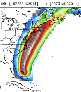
Potential Rainfall for Irene over the Northeast.
 More on the Boston area impacts in a later post.!


Friday, August 26, 2011

Irene - Hurricane Watches issued.

Hurricane Watches have been issued for all of the Massachusetts coastline this morning, with the entire state under a Tropical Storm Wind Watch as well.

A hurricane WATCH means, hurricane conditions are possible within 48 hours.

Hurricane Watches are in magenta, the track of the storm is from the National Hurricane Center.
Irene should track a bit further east I feel and has a great potential to be over the Boston area between 5 and 9 PM Sunday.  Any location to the right of the above track can expect wind gusts over hurricane force 74mph +.  Heavy rain will also be a problem for ALL of New England, up to 10" of rain could fall on already wet ground.   Wet soil will easily knock doen trees.

Significan storm surge and waves are also expected along the south coast.  Storm surge for Boston will be lower due to the block effect of Cape Cod,  but Buzzards Bay, Narraganset Bay, and all of coastal Southern RI and MA could see extremely high water levels. 

Below is this mornings discussion from the NWS in Boston. I feel it is a good read.

Hurricane Statement from Boston

IMPACTS...

1) HIGH SURF AND DANGEROUS RIP CURRENTS HAVE ALREADY ARRIVED ON THE
   SOUTH COAST

2) HEAVY RAIN WITH MODERATE TO MAJOR FLOODING - ESPECIALLY ON THE
   WEST SIDE OF THE STORM

3) VERY STRONG DAMAGING WINDS - ESPECIALLY ON THE EAST SIDE OF THE
   STORM

4) LARGE AND POTENTIAL DESTRUCTIVE STORM SURGE/COASTAL FLOODING
   ALONG THE SOUTH COAST

5) A FEW WEAK TORNADOES ARE POSSIBLE ON THE NORTH AND NORTHEAST SIDE
   OF IRENE. 


TECHNICAL DISCUSSION...
IRENE WILL HAVE A VERY SIGNIFICANT AND DAMAGING IMPACT ON SOUTHERN
NEW ENGLAND.  WE ARE STILL MORE THAN 48 HOURS OUT FROM AN POTENTIAL
LANDFALLING HURRICANE IN SOUTHERN NEW ENGLAND.  THIS MEANS THERE IS
CONTINUED MODEL UNCERTAINTY ON THE TRACK...STRENGTH AND EXACT
HAZARDS.  HOWEVER...ITS BECOMING PRETTY APPARENT THAT NO MATTER
WHERE IT TRACKS THIS SHOULD BE A VERY SIGNIFICANT AND POTENTIALLY
DAMAGING EVENT ACROSS SOUTHERN NEW ENGLAND.  FOR WHAT ITS
WORTH...THE CONSENSUS OF THE 00Z MODEL DATA HAS TRENDED A BIT BACK
TO THE EAST.  CONSENSUS WOULD HAVE LANDFALL IN THE VICINITY OF LONG
ISLAND/CONNECTICUT OR RHODE ISLAND.  HOWEVER...THE OPPORTUNITY FOR
TRACKS AS FAR WEST AS THE MASS/NY BORDER...TO FAR SOUTHEAST MA
REMAINS IN THE CONE OF UNCERTAINTY.  WE SHOULD SEE THE MODELS BEGIN
TO REALLY LATCH ONTO THE TRACK OVER THE NEXT 1 TO 2 MODEL
CYCLES...AS WE MOVE INSIDE 48 HOURS FROM POTENTIAL LANDFALL.

WITH ALL THAT SAID...A HURRICANE WATCH HAS BEEN ISSUED FOR THE
COASTAL SECTIONS AND TROPICAL STORM WATCHES FOR MOST OF THE INTERIOR.

IT APPEARS THAT THE STAGE IS BEING SET FOR A CLASSIC PREDECESSOR
RAIN EVENT SATURDAY NIGHT...OUT AHEAD OF IRENE.  TROPICAL MOISTURE
WILL STREAM NORTHWARD AHEAD OF IRENE AND WILL RESULT IN INCREASING
BANDS OF HEAVY RAIN SHOWERS.  THE OVERALL AREAL COVERAGE AND
INTENSITY SHOULD INCREASE TOWARDS MORNING.  THE MODELS APPEAR TO
HAVE SPED UP THE TRACK OF IRENE ON THIS RUN...MOST LIKELY MAKING
LANDFALL AS A CATEGORY 1 HURRICANE.  HOWEVER...THERE STILL IS A LOW
PROBABILITY THAT IT MAKES LANDFALL AS A LOW END CATEGORY 2.


MORE DETAILED HAZARDS...

1) HIGH SURF AND DANGEROUS RIP CURRENTS:
SWELL FROM IRENE HAS ALREADY RESULTED IN THE DEVELOPMENT OF HIGH
SURF AND DANGEROUS RIP CURRENTS...ESPECIALLY ON OCEAN EXPOSED SOUTH
FACING BEACHES.  THESE CONDITIONS WILL BECOME PROGRESSIVELY WORST
TODAY AND INTO THE WEEKEND AND SWIMMING IS NOT RECOMMENDED.

2) HEAVY RAIN WITH MODERATE TO MAJOR FLOODING POSSIBLE:
A FLOOD WATCH HAS BEEN ISSUED FROM SATURDAY NIGHT THROUGH SUNDAY
NIGHT FOR ALL BUT THE CAPE AND ISLANDS.  WHILE THE EXACT TRACK
REMAINS UNCERTAIN...5 TO 10 INCHES OF RAIN WITH LOCALLY HIGHER
AMOUNTS ARE POSSIBLE TO THE LEFT OF THE TRACK.  THIS WILL LIKELY
BRING MODERATE TO MAJOR URBAN AND RIVER FLOODING TO PARTS OF THE
REGION.  AT THIS POINT...INTERIOR SOUTHERN NEW ENGLAND IS AT
GREATEST RISK FOR MORE SERIOUS FLOODING.  NONETHELESS...THE BOSTON
TO PROVIDENCE CORRIDOR STILL HAS THE POTENTIAL FOR FLOODING
ESPECIALLY IF THE TRACK SHIFTS EAST IN LATER MODEL RUNS.

3) VERY STRONG DAMAGING WIND GUSTS - ESPECIALLY ON THE EAST SIDE:
AS MENTIONED EARLIER...MODEL CONSENSUS FAVORS IRENE MAKING LANDFALL
AS A CATEGORY 1 HURRICANE WITH A LOW PROBABILITY OF A LOW END
CATEGORY 2.  THERE IS STILL SPREAD AND UNCERTAINTY OF THE TRACK AS
WELL.  BASED ON MODEL CONSENSUS LANDFALL SOMEWHERE IN THE LONG
ISLAND/EASTERN CT OR RHODE ISLAND AREA SEEMS REASONABLE...BUT STILL
MORE THAN 48 HOURS OUT SO NOTHING IS SET IN STONE.
REGARDLESS...EXPECT VERY STRONG DAMAGING WIND ESPECIALLY EAST OF THE
CENTER.  THE POTENTIAL FOR WIDESPREAD POWER OUTAGES AND TREE DAMAGE
EXISTS WITH IRENE.  ITS POSSIBLE THAT EXTENDED POWER OUTAGES AFFECT
A LARGE PORTION OF SOUTHERN NEW ENGLAND SO PEOPLE SHOULD BE PREPARED.

4) LARGE AND POTENTIALLY DESTRUCTIVE STORM SURGE/COASTAL FLOODING:
COASTAL FLOODING IS EXPECTED ACROSS BOTH COASTS AS A RESULT OF
HURRICANE IRENE.  HOWEVER...THE AREA OF EXTREME CONCERN IS ALONG THE
SOUTH COAST AND FOR BOTH THE SUNDAY MORNING AND EVENING TIDES.  THIS
HAS THE POTENTIAL TO BE A VERY DANGEROUS AND LIFE THREATENING
COASTAL FLOOD EVENT.  WHETHER THIS COMES TO FRUITION WILL DEPEND
UPON THE EXACT TRACK AND TIMING.  ITS SO TOUGH BECAUSE THE CHANGE IN
TIMING BY JUST A FEW HOURS WILL HAVE HUGE IMPACTS ON THE STORM SURGE
POTENTIAL.  HOWEVER...PEOPLE LIVING ON THE SOUTH COAST SHOULD BE
PREPARED FOR THIS POTENTIAL.

5) A FEW WEAK AND SHORT LIVED TORNADOES ARE POSSIBLE:
HURRICANE IRENE WILL HAVE THE POTENTIAL TO PRODUCE A FEW WEAK
SHORT-LIVED TORNADOES MAINLY ON THE NORTH AND NORTHEAST SIDE OF THE
SYSTEM.  IN FACT...IF THIS DID OCCUR THERE PROBABLY WOULD NOT EVEN
BE THUNDER.  THIS MAINLY A RESULT OF EXTREME DIRECTIONAL AND SPEED
SHEAR.

Thursday, August 25, 2011

Irene 10 PM Update.

Tonight, Irene is strengthening just north of the Bahamas and they eye is becoming clear on satellite imagery as well as radar from south Florida.

Irene at 10PM August 25.
So, folks in Boston want to know, what is going to happen with Irene?

Well my friends, there are 2 possible tracks that Irene could take. Usually we are talking about the track out to sea or the track just over Boston. However this time, the track over Boston seems the least likely of the track as it appears to be going further WEST, over Long Island and CT.

One model run that I like and displays the hurricane well is below.
The white areas show hurricane force winds with one of the models tracking furthest east over Boston. This is still a very good probability.
This is what the weather map would look like at 2 PM Sunday with the above model.

HWRF Model 2PM Sunday  The eye of Hurricane Irene about to make landfall near Newport, RI. If this model proves true, the eye would move directly over Boston at 5 PM with a wind of 75-85mph gusting to 90-100 mph. 
With the above scenario, areas to the east of the eye would get the highest wind speeds and of course Narraganset and Buzzards bay could experience a major storm surge.

However, there is also a cluster of models that track Irene directly over New York City. This would still give Boston some good winds up to 65-75 mph, but not as bad. This is the worst case scenario possible and if this comes to be, NYC and Long Island will never be the same again.  It has been posted that the highrise sky scrapers could experience with an 80mph hurricane winds over 120 at the highest floors.


What I would like to say now tho is, Irene is HUGE!  If I were to super-impose Irenes winds field over New England right now, the extent of Tropical Storm force winds would stretch from P-town to the Finger Lakes in NY, almost 375 miles across would get tropical storm force winds and hurricane winds extend out 130 miles across, a very large hurricane.

Where am I leaning with my forecast on Irene.  I do think that a gradual nudge to the east will take place and Boston will be in for a rough time.

Rain will begin Saturday evening and continue until the hurricane passage Monday morning.

Tropical Storm force winds (>39mph arrive around 7 AM on the south shore of RI and MA and Cape Cod.   Boston - 9-11 AM.

Hurricane conditions arrive at 1 PM on the south coast and the eye makes landfall between mid Long Island and Newport, RI at 2 PM.

The eye of Irene tracks near or close to Boston around 3-5 PM, with winds possibly up to 80 mph.

I cannot discount the track over NYC, but I think Irene will be nudged further east at this time.

Irene and other hurricanes - a size up!

Irene - August 25, 2011 7 PM EDT
Earl - 2010
Ike 2008
Katrina 2005

A look back in time.. some infamous New England Hurricane headlines!

1869 Hurricane
1893 Hurricane
1936
1938
1938
1944
Donna 1960
Gloria 1985

Wednesday, August 24, 2011

Irene Expectations - Wednesday PM Update

Here is what we can expect in the Boston area from Irene based on the Wednesday evening forecasts.

11 AM Friday - A Hurricane Watch could be issued Friday afternoon for much of the area.

NOW would be a good time to preliminarily prepare. (See below)

2-4 PM Saturday - A cold front and outter bands of rain approach New England around  well ahead of the hurricane.

7 AM Sunday - Heavy rains begin to fall around.

8 AM Sunday - Tropical storm force winds (40mph+) reach the Cape and south coastline by 8 AM.

9 AM Sunday - Wind speeds gradually increase, water/surge begins to rise along the south coast. Strong east winds Northshore & NH coasts will increase wave heights.


1-3 PM Sunday - Irene makes first landfall on eastern Long Island as a category 2 hurricane 96-110mph winds with higher gusts. Rainfall could approach 10" over parts of New England and isolated tornadoes are possible.

2-4 PM Sunday - Eye of Irene makes 2nd landfall (at this time from Bridgeport, CT to New Bedford, MA.

One Model depiction of landfall of Hurricane Irene in New England at 2 PM. Green areas are hurricane force winds. 


5-7 PM Sunday - Eye of Irene tracks near Boston with winds 75-95 mph, strongest at the coast.

8 PM Model cloud depiction of Irene with the eye/center over the MA/NH border.


8-10 PM Sunday - Eye of Irene is near Rochester, NH  to Portland Maine 75 mph. Rain ends for Boston area. Winds die down.


Good morning Irene

I did not have time this morning to get a good forecast or thoughts together, so instead. I will post what the NWS in Boston has said about Irene. Very good thoughts.


***HURRICANE IRENE WILL IMPACT SOUTHERN NEW ENGLAND THIS WEEKEND TO
SOME DEGREE BUT ITS TRACK AND POTENTIAL HAZARDS REMAIN HIGHLY
UNCERTAIN***

THIS WEEKEND...
HURRICANE IRENE WILL IMPACT SOUTHERN NEW ENGLAND THIS WEEKEND TO
SOME DEGREE...BUT ITS TRACK AND AFFECTS REMAIN UNCERTAIN.  WE ARE
STILL MORE THAN 96 HOURS AWAY FROM A POTENTIAL DIRECT IMPACT FROM
IRENE.  THINK ABOUT ALL THE NOREASTERS OVER THE WINTER AND THE
UNCERTAINTY IN TRACK AND IMPACTS EVEN INSIDE 60 HOURS.  THE
POTENTIAL DOES EXIST FOR HEAVY RAIN/SIGNIFICANT FRESH WATER
FLOODING...ALONG WITH STRONG DAMAGING WIND GUSTS AND A STORM SURGE
RESULTING IN COASTAL FLOODING.  THIS POTENTIAL WILL DEPEND ON THE
EXACT TRACK AND STRENGTH OF IRENE WHICH REMAINS HIGHLY UNCERTAIN.

THE ENSEMBLE GUIDANCE REALLY SHOWS THE MODELS IN TWO GENERAL CAMPS.
THE FIRST GROUP IS CLUSTERED ACROSS LONG ISLAND AND INTO CT...WHILE
THE SECOND GROUP IS ACROSS FAR SOUTHEAST MA/CAPE/ISLANDS.  THEN
THERE ARE A FEW OUTLIERS THAT ARE EVEN FURTHER WEST AND/OR EAST OF
THE TWO MAIN GROUPS.  IT IS EVIDENT THAT THERE HAS BEEN AN EASTWARD
SHIFT AMONGST THE 00Z GUIDANCE.  WILL HAVE TO SEE IF THIS TREND
CONTINUES OVER THE NEXT 12 TO 24 HOURS OR IF ITS JUST A MODEL
ADJUSTMENT.

THE SPREAD CONTINUES TO POINT TO UNCERTAINTY IN HOW EXACTLY IRENE
WILL IMPACT SOUTHERN NEW ENGLAND.  THE MODELS DO SHOW THIS BEHAVING
AS A CLASSIC TROPICAL SYSTEM IN OUR REGION.  THAT MEANS THE GREATEST
POTENTIAL FOR THE HEAVIEST RAIN/SIGNIFICANT FRESH WATER FLOODING
WILL BE TO THE LEFT OF THE TRACK...WHILE THE POTENTIAL FOR THE
STRONGEST WINDS AND HIGHEST STORM SURGE/COASTAL FLOODING TO THE EAST
OF THE CENTER.  NOW JUST BECAUSE YOU END UP TO THE LEFT OF THE TRACK
DOES NOT MEAN THAT YOUR OUT OF THE WOODS FOR SOME COASTAL
FLOODING...THE ISSUES WOULD JUST BE WORST TO THE EAST OF THE
CENTER.  ESPECIALLY SINCE ASTRONOMICAL TIDES ARE HIGH AND WERE GOING
TO SEE VERY HIGH SEAS AND SWELL WITH THIS SYSTEM.

THE BOTTOM LINE IS IRENE WILL IMPACT IN SOMEWAY ACROSS THE REGION.
HOWEVER...CONDITIONS WILL BE SIGNIFICANTLY WORST IF A TRACK FURTHER
WEST VERIFIES WITH LESSER IMPACTS IF THE EASTERN SOLUTIONS VERIFY
EXCEPT FOR THE POTENTIAL OF HEAVY RAIN/FLOODING.  THERE IS EVEN A
LOW PROBABILITY THAT A SIGNIFICANT SHIFT TO THE EAST WOULD CONFINE
THE HEAVY RAIN/FLOOD POTENTIAL TO FAR SOUTHEAST NEW ENGLAND.

AS MENTIONED EARLIER...THE 00Z GUIDANCE DID MAKE AN EASTWARD SHIFT
SO WILL HAVE TO SEE IF THIS TREND CONTINUES OR WAS JUST AN
ADJUSTMENT.

FORECAST DETAILS THIS WEEKEND...
REGARDLESS OF THE TRACK...IT DOES APPEAR THE STAGE IS BEING SET FOR
A PREDECESSOR HEAVY RAIN EVENT SOMETIME SATURDAY AND ESPECIALLY
SATURDAY NIGHT.  DEEP TROPICAL MOISTURE STREAMING WELL IN ADVANCE OF
IRENE WILL INTERACT WITH A MID LEVEL TROUGH.  THIS HAS THE POTENTIAL
TO PRODUCE HEAVY RAIN AND FLOODING AHEAD OF IRENE INTO EARLY SUNDAY
MORNING.

AS MENTIONED EARLIER...PLENTY OF SPREAD AND UNCERTAINTY WITH THE
TRACK OF IRENE ALTHOUGH THE 00Z MODEL RUNS DID SHOW A TREND
EASTWARD.  IT DOES APPEAR THAT THE MAIN IMPACTS WILL BE SUN INTO
SUNDAY NIGHT.  POTENTIAL HAZARDS INCLUDE HEAVY RAIN/SIGNIFICANT
FRESH WATER FLOODING...STRONG TO DAMAGING WINDS...STORM SURGE AND
ASSOCIATED COASTAL FLOODING.  AGAIN...WHILE IRENE WILL IMPACT OUR
REGION TO SOME DEGREE IT WOULD BE WORST IF THE TRACK ENDS UP IN THE
WESTERN ENVELOP OF SOLUTIONS.

Tuesday, August 23, 2011

Irene Update - 11PM

The 11 PM Advisory from the National Hurricane Center place the center of hurricane Irene just south of New York City at 11PM on Sunday night.

  • The map here shows the official position of Irene as a category one hurricane near NYC.
  • The dots, indicate landfall locations of past notable New England hurricanes.
  • The lines indicate various model tracks for Irene
  • The yellow shading is the NHC cone of uncertainty, where Irene could track in 5 days.
 Although we are 5 days away from a very possible impact by Irene, if the current forecast holds, any location to the right of the hurricane track can expect a very large storm surge, damaging winds well inland and extremely heavy rainfall. 

With over 4-10 inches of rain that have fallen in the past weeks over parts of NY and New England, a hurricane can easily cause severe tree damage, as root systems are weakened by moist ground. 

One of the model runs takes Irene's eye over Newton, Woburn, Ipswich, Newburyport.  

More information to come tomorrow morning.

Some analog storms to look at with Irene.


Sometimes , when forecasting models help, but also looking at the past can also help. Here is one example of using a past hurricane (Belle 76) with a very similar upper air flow in determining where Irene may go.

500 mb chart for August 8, 1976 - Hurricane Belle


Forecast 500mb Chart for August 27, 2011 - Irene

8/23/11 A Hint of Fall...

Opening up those windows and turning the A/C off was quite nice overnight.  A low of 63 at the airport and a dewpoint of 51 with many rural areas getting into the 50's overnight gave a nice feeling of an early fall morning to the air!


Today will be nice and coolish, with a high near 79 and overnight lows falling back into the lower 60s in the city to lower 50's in the rural valleys.

Wednesday - Sunshine again with comfortable temperatures around 80 and dry, although it will become increasingly more humid as the evening wears on.

Thursday - A cold front will approach New England, the wind will shift to the southwest and become quiet breezy. (This is not part of Irene). Thunderstorms could develop in the afternoon and continue into the night. Highs will be in the low to mid 80s.

Friday - Another nice day on Friday, dry and comfortable. With highs in the upper 70's.


Weekend Outlook - Tropical Cyclone Irene will make her way from the Carolinas to New England. Moisture should start streaming northward in the form of high cirrus clouds during the day on Saturday.  Moisture should hold off at least until Sunday.  The track of Irene is still too far out to pinpoint exactly where and when she will affect New England. However if you have weekend plans along the CT, RI, MA, NH or Maine coast. Think about what you may do if Irene is forecast to impact those areas.

Possible tracks of Irene into next Monday. The official forecast at 5AM Tuesday calls for Irene to strike North Carolina. But anywhere from South Carolina to Massachusetts could be impacted by Irene later this week.


  • If you have plans to go to the Cape, you know how traffic is on a normal summer weekend on Route 6.  Think about many people trying to get off the Cape during a hurricane. Plan accordingly.
  • If you take a ferry to P-town or the Vineyard or Nantucket for the weekend and you need to be back to town on Monday morning.  Think about how you may get home if a storm interrupts ferry service.

  • If you have beach plans for Sunday, at this point do not cancel them, but be aware that you might have to change your plans.

  • Also, just some common sense ideas for people who live near the water or even inland.  Buy some batteries, keep your gas tank filled, buy a $25 power inverter for your car if the power goes out to then charge your electronic devices. (they are great for trips not just storms).

Monday, August 22, 2011

Irene and the models (For New England) and NOT a forecast...

This is a GFS model run comparison for Hurricane Irene and impacts in New England. These are not official forecasts, but for use to see trends and possible impacts with each model run. 

the 2AM 8/23 GFS brings Irene to the MA coast with the eye over Martha's Vineyard/New Bedford then over Provincetown.  The model runs have been consistent, wobbling between Cape Cod and Long Island for this coming Sunday into Monday. 964mb


The 2PM GFS (8/22) model has Irene, as a hurricane over New York City, what may be an eye or calm center is over Bridgeport, Ct at 11 AM on Monday. The strongest winds are on the right front quadrant of the storm, which could bring a significant storm surge into RI, Buzzards Bay and Narraganset Bay, MA.   Of interest with this track is that the storm hugs the entire Atlantic coastline, bringing hurricane conditions all the way into New England. (Note, the red line is from the previous forecast model run)

The 8 AM GFS (8/22) model had Irene missing the Carolinas and therefore not interacting with land maintaining a stronger hurricane over Buzzards Bay in MA as a 965mb hurricane, which would be more destructive for Nantucket and Cape Cod.  The red line indicates this models track.

The 2AM GFS (8/22)model had Irene, (after a Carolina strike), moving up the coast and being a hurricane just south of New York City at 2 AM on Monday August 29.  A 976mb hurricane at that

Irene - Into next weekend. What is your plan?

Much talk will be on Irene over the next week.  The models are being consistent with a track near the SC coast, then hugging the coastline from NC and possibly remaining offshore until it makes a landfall on Long Island and into New England possibly as a hurricane or very strong tropical storm. 

Noting - with a track like this, the worst part of the storm would be to the right of the likely track which would be storm surge and wind. 

This is still a week out forecast and much can change. As always stated one should never focus on the direct track this far out.

However it is a good time to think about what you may do if you live on the coast or are subject to coastal flooding.   Do you have beach plans or boating plans for next Sunday and Monday or do you need to get to Nantucket, Martha's Vineyard or P-town by ferry Monday morning.    Just plan ahead.


Sunday, August 21, 2011

Sunday Update - Thunderstorms & Irene

Thunderstorms will approach the Boston area around 4 PM today, some storms could be severe and produce small hail, gusty winds and heavy rainfall.  The rain will continue as a cold front advances slowly across the area.


Tropical Storm Irene is near Puerto Rico this afternoon and will track on a West Northwest track. Possibly reaching the Florida coast by Friday then track north toward the Carolinas with a gradual turn in the direction of New England. Any effects from Irene would not be felt until next Sunday at the earliest. Again, it is way too soon to say where Irene will track, but does bear watching.

Irene at 2 PM on Sunday with potential tracks leading into the upcoming week. It is important now not to focus on one individual track for the US, but to know that there is a storm worth watching.


Taken from http://meteorologicalmusings.blogspot.com/2011/08/potential-hurricane_21.html

  • Keep your car's gas tank full. Spend $25 or so to buy an electrical inverter
  • If you have dispersed family (i.e., kids in college, elderly relatives you might need to help evacuate, etc.), talk with them now about contingencies if your area is put under a warning later this week
  • Make sure you have a battery-powered TV or radio with fresh batteries
  • Get any medical prescriptions refilled now, even if you haven't completely run out.
That's it for now...enjoy the rest of your weekend. There is no need to be concerned until watches or warnings are issued.