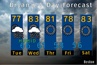
The soggy tropical air mass that has dropped nearly 7 inches of rain over parts of New England over the past few days has pushed away and in its place dry, refreshing high pressure is now in control.
Thursday - Bright sunshine and lowering dew points will make for a great day. Highs will be in the lower 80's and the dew point will fall throughout the day into the low 50s.
There may be a few clouds in northern NH/VT with a sprinkle later today if your plans have you going north. A few high clouds may wisp by on the south shore
Tonight - The dry air will also provide a comfortable evening as well with many areas seeing low 50's. Some outlying areas could see some upper 40's.
Friday - A clear dry day with highs in the lower 80's.
Weekend Outlook - Saturday looks to be the better of the two days with sunshine again a few late day clouds with a high in the low 80s. Humidity and the chance for rain increase by Sunday.
The Tropics!
We could start seeing some more named storms in the Atlantic come later this weekend and into next week as we rise into the peak of hurricane season.
My Personal Weather Station
Weather at Boston, Logan International Airport, MA - via NOAA's National Weather Service
Current Watches, Warnings and Advisories for Massachusetts Issued by the National Weather Service
Thursday, August 11, 2011
Tuesday, August 9, 2011
8/9/11 Quick Forecast for Tuesday
Sun will give way to increasing clouds by 1 pm today.
A brief line of showers will push through around 2:30 PM
Another line will develop around 4 PM.
A heavy, steadier area of rain will come in around 6 PM and continue for the remainder of the evening hours.
Low pressure will be slow to move out and continue the threat of showers for the day on Wednesday. Drier weather moves in on Thursday and Friday.
A brief line of showers will push through around 2:30 PM
Another line will develop around 4 PM.
A heavy, steadier area of rain will come in around 6 PM and continue for the remainder of the evening hours.
 |
| Radar depiction for 8 PM tonight. Rain with heavier showers over all the state. |
Monday, August 8, 2011
7/8/11 A soggy tropical connection!
The heavy rains of yesterday were reminiscent of those associated with a tropical air mass of that in Florida. Well believe it or not, the moisture in the air mass can be attributed to a landfalling tropical storm in Texas, "Don", way back on July 29! (See details below).
For today, the tropical air mass is still in place with dew points in the lower 70's. It will feel very humid. This air mass sticks around until Wednesday when a cold front will ring out the moisture in the form of more heavy showers and storms. This will be followed by a drying trend through the weekend.
Sunday's Rain - A tropical Connection.
Although Don dissipated quickly upon landfall on the Texas coast, its tropical moisture laden air mass continued around an area of high pressure and moved into Wyoming and Montana. Then got caught up in the westerly flow and tracked into the plains and eventually into the northeast US.
Below is the moisture track on the bottom right of Don (marked with a green X). Don's moisture got caught up in with the monsoonal moisture in the west, with a portion of it tracking North into Canada early in the week. The other portion, remained and tracked across the country.
There were other factors involved with this rain event, but it was interesting to note where some of the source came from.
The highest total was 3.88 inches in Hebron, CT. Some local totals included:
WEST PEABODY          2.66
   LYNN                  2.30
   SALEM                 2.25
   ARLINGTON             2.59
   WAKEFIELD             2.52
   NATICK                2.32
   WAYLAND               2.20
   AUBURN                3.60
   WEBSTER               2.63
 |
| Flooded street in Swampscott, MA on Sun, August 7, 2011. |
Subscribe to:
Comments (Atom)


