My Personal Weather Station

Weather at Boston, Logan International Airport, MA - via NOAA's National Weather Service

Current Watches, Warnings and Advisories for Massachusetts Issued by the National Weather Service

Friday, July 1, 2011

7/01/11 Wicked bad humidity returns, afternoon storms Sunday!

Summertime weather to headline the holiday weekend.  Sunday evening will feature heavy thunderstorms.

Friday - A dry day overall, a few clouds that are seen over NH and VT may work their way into the Boston area by mid afternoon. A spot, but light shower could be possible especially between 2 and 5 pm today in some locations inland.  A sea breeze will develop at the coast keeping temperatures in the upper 70s where inland areas reach the lower 80s. The sea breeze should also keep coastal areas in the clear for the day. You will notice the humidity levels increasing throughout the day.

Saturday - A dry day but becoming muggy by the evening hours. Coastal locations should once again stay cooler and it will be coolest on the Cape and South Shore as well. Highs in the upper 70s to lower 80s.


Sunday - The day looks to be good, but it will be very humid and warm. It will feel like it is in the upper 80s for most locations and it will be very sticky. The dewpoint will rise to around 70-74, which is known as a tropical air-mass. It will be oppressive!


A slow moving cold front approaches New England on Sunday evening. With such an airmass in place, the atmosphere is very moist and possible downburst type thunderstorms are possible across the region. What this means is that thunderstorms are capable of bringing very heavy rainfall and gust winds.  Flash flooding is a concern with such storms, so please take caution if you are near a stream, creek or run off area.

Right now the timing is as follows:  
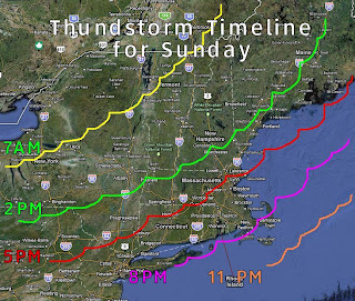
Timeline for the front edge of thunderstorms. 
  • 2pm  NH/CT River Valley
  • 5pm  Northshore MA - S NH
  • 8pm  Cape Ann to Plymouth 
  • 11pm Ptown - Cape Cod

I will update these time frames over the weekend to give you a better outlook, but you can prepare accordingly now if need be with any outdoor activities. 


Monday -  Slowly drying out throughout the day.  More humid on the Southshore and Cape. Highs in the mid 80s most locations. Chance of an afternoon thunderstorm.

Thursday, June 30, 2011

6/30/11

Today - Just beautiful last day of June weather. Sunny, dry and warm! High of 80!


Friday - A few more clouds around, perhaps a shower esp north and in NH, but brief and in the afternoon.  Highs near 80. Cooler right at the coast with a sea breeze kicking in after 1 PM. Greatest chance for a rain shower between 4 & 8 PM.

Saturday - A few clouds from time to time, but dry and warmer, slightly more humid, increasing clouds late in the day with an overnight shower possible.

Sunday - Hot and humid, lots of hazy sunshine! Highs nearing 90. Chance for a typical summer afternoon thunderstorm.

Monday - Less humid but still warm highs in the mid 80s.


Weekend forecast highs across the Northeast. Blue are water temperatures.

Wednesday, June 29, 2011

6/29/11 The 4th Forecast Boston & Cape + Arlene

Good morning!  The rain has pushed out of New England this morning and the clouds will thin out by 10 - 11 AM, as it is clearing out in the Berkshires and NY.

Today - Morning clouds will thin out and the humidity levels will begin to drop this afternoon as a cold front slowly pushes through so expect some bright sunshine and comfortable temperatures.  There might be a brief shower in the early afternoon with any unstable air pushing through.  The cooler air will take its time getting here, so with sunshine, expect temperatures to climb into the 80s.  There is a greater chance for a thunderstorm in RI and the Cape today.

Thursday - Very dry, comfortable, cool overnight temps. Refreshing!  Overnight low of 55 outside the city, 60 in the city.  High of 80.  Some models want to bring a quick late day shower to Northern MA and Southern NH. Hard to see it with it being so dry, but just want to mention it just in case you happen to be the one person who sees a drop of rain. I don't think you will.


Friday - Another good day, although you will notice the humidity levels increase later in the day. Coolest at the Cape and Islands and in the Berkshires where it will be in the upper 70s.  low to mid 80s elsewhere.

Saturday - More humid, warmer, southwest wind will limit any sea breeze. High in the mid to upper 80s. Cooler on the Cape.

Sunday -  Same as Saturday, warmer highs in the 80s to near 90. Coolest at the Cape

4th of July - More widespread 80s to lower 90s. Sunny.  Less Humidity.

As with any summer type of weather such as Sat and Sunday, the possibility of a scattered thunderstorm is always possible in the mid to late afternoon.

P-town Forecast - Increasing humidity on Friday. A possible shower or thunderstorm Late on Saturday or overnight into early Sunday morning. Clearing out Sunday morning.

Tropical Storm Arlene

The first tropical storm of the season has formed in the Gulf of Mexico and will strike the Mexican Coast. No threat to the US, which could use the rainfall.

Tuesday, June 28, 2011

Tropical Update - Possible Depression forming in the Gulf

41 mph surface wind speeds found with tropical disturbance


AN AIR FORCE RESERVE UNIT HURRICANE HUNTER AIRCRAFT INVESTIGATING
THE BROAD AREA OF LOW PRESSURE OVER THE BAY OF CAMPECHE WAS ABLE TO
LOCATE A LOW-LEVEL CENTER OF CIRCULATION.  HOWEVER...THE ASSOCIATED
SHOWERS AND THUNDERSTORMS ARE NOT SUFFICIENTLY ORGANIZED TO
DESIGNATE THE SYSTEM AS A TROPICAL DEPRESSION AT THIS TIME. 
UPPER-LEVEL WINDS ARE LIKELY TO BECOME MORE CONDUCIVE FOR
DEVELOPMENT...AND THE LOW HAS THE POTENTIAL TO BECOME A TROPICAL
DEPRESSION AT ANY TIME.  THERE IS A HIGH CHANCE...90 PERCENT...OF
THIS SYSTEM BECOMING A TROPICAL CYCLONE DURING THE NEXT 48 HOURS AS
IT MOVES WEST-NORTHWESTWARD AT 5 TO 10 MPH.  INTERESTS ALONG THE
EAST COAST OF MEXICO IN THE STATES OF TAMAULIPAS AND VERACRUZ
SHOULD CLOSELY MONITOR THE PROGRESS OF THIS SYSTEM...AS A TROPICAL
STORM WARNING MAY BE REQUIRED FOR PORTIONS OF THESE AREAS TONIGHT
OR EARLY WEDNESDAY.  LOCALLY HEAVY RAINS AND GUSTY WINDS SHOULD
CONTINUE OVER PORTIONS OF EASTERN MEXICO OVER THE NEXT DAY OR TWO. 

6/28/11 You can't ask for much better +4th 4cast!

I am happy to report that the only fly in the ointment for the forecast will be overnight tonight into the morning hours tomorrow.  Then if you like summer time weather and dry conditions, you will have it!

The forecast remains the same as yesterday pretty much.

Today, sun with some scattered clouds and seasonable with a high of 82.  Increasing clouds late in the day. Cooler on the Cape, warmer inland and in the CT River Valley.


Wednesday, a cold front pushes through during the early morning hours, will trigger some showers and thunderstorms for the morning commute clearing out by 10AM, should be a sunny day and a bit cooler with a high of 77.

Thursday and Friday - Warm and DRY!  Comfortable humidity, plenty of sunshine highs in the lower 80s. Nighttime lows in the 50's away from the city.

Expect rain and thunderstorms Wednesday from around 5 AM - 10 AM, then clearing.


4th of July Weekend - Slight chance of morning showers on Saturday but light and scattered in nature, clearing for Sunday and Monday. More humid and warmer with highs in the mid 80s.

Friday is dry and less humid. Sat and Sun are typical summer days in which a thunderstorm cannot be ruled out. 4th of July - Sunny and dry!  Warm inland, cooler at the beaches.

Monday, June 27, 2011

Sea Breezes and Cloud Features


I love when a satellite image tells a good story of the weather.

There is so much to see in the picture. Sea breezes, lake breezes, lake shaddows, valley shaddows.

  • Cape Cod is in the clear do to the stabilization of the ocean air.
  • The Sea Breeze has moved in from NH all the way to NYC. 
  • A sea breeze convergence is over Long Island. 
  • The Lake Champlain Valley is clear.
  • The Susquehanna River Valley in NY & PA is well defined.
  • Finger Lakes & Oneida Lake shaddows over NY
  • Sea Breeze over Buzzards Bay & Narraganset Bay
  • Connecticut River Valley Shaddow

The air is generally unstable. The sun hits the earth, which now has a lot of moisture in it from days of rain, the heat the rebounds back into the atmosphere taking the moisture with it and forming clouds.

Where the air is more stable, cooler water creates stability, also air being pushed down into a valley creates stability, there are less or no clouds.  The wind then will push this stable air inland or if over a lake or river, primarily downwind or overhead of such areas.

6/27/11 A decent week ahead.. preview July 4th

This week looks to be so much easier to forecast, and you will like the results!  Unless you are a cold, rainy, cloudy type of person.


Monday - a typical summer day here in Boston.  Clear this morning, a sea breeze kicks in around 1 PM. Will see a cool down right along the coast. Inland highs in the mid 80's, coast, warmest at noon then dropping into the mid 70s - refreshing!  Spot chance for a very isolated thunderstorm along the sea breeze later today.

Tuesday - Clear in the morning, then some high clouds move in midday,  sea breeze forms again mid day, cooler right at the coast. More clouds south than north. A cold front approaches over night.

Wednesday - Cool front pushes through early to bring in some showers for the morning commute. The front will usher in drier air, but temperatures will remain nice and warm. Clearing out by 9AM.


Your 4th of July Weekend Outlook (Boston)


Friday - dry and warm with comfortable humidity. Saturday, a weak trough approaches, more clouds than sun, afternoon showers likely. Sunday, warmer isolated PM thunderstorms, warm more humid. Monday, drier and a bit cooler.
Your 4th of July Weekend Outlook (Upstate NY)

Friday - cool start to the morning, lows in the 40s! Warming up rapidly.  Saturday - Overnight/Morning showers, a bit more humid hot!  Sunday - Scatter thunder possible, mostly dry. Monday- pleasant!