My Personal Weather Station

Weather at Boston, Logan International Airport, MA - via NOAA's National Weather Service

Current Watches, Warnings and Advisories for Massachusetts Issued by the National Weather Service

Saturday, March 24, 2012

3/24/12 Here cometh the cold..

I know many of you are in shock this morning. Temperatures are hovering around normal this morning. Yes, this is what it is supposed to feel like at the end of March.
A flow off of the ocean will keep coastal temperatures lower. Inland areas over the CT River Valley will warm into the 60s. Rain showers are possible today in NH and VT.
Saturday across Boston will be mostly dry. A few showers are possible early over Vermont and New Hampshire. Then showers will move into Western Mass and CT later this evening. A brief shower may move through between 4 and 5 PM this afternoon in Boston.

As the area of Low pressure that is over the Ohio Valley moves to the east coast, it will get a little bit stronger and it will tap into the colder air that the Canadian High pressure has produced by Monday and Tuesday.
The weather pattern across the Northeast has changed with an area of High pressure from Canada taking over. The flow is allowing air to flow in from the north instead of the Bermuda high, which brings air in from the south. An area of weakening low pressure will bring rain showers late on Saturday and Sunday. 
A cold snap (Which is actually normal for this time of year) will occur on Monday and Tuesday. Nighttime lows will drop into the 20s and 30s across Mass and into the teens in NH, VT and Maine. Expect daytime highs in the 40s.
The cold spell t will drop temperatures into the 20s overnight both Monday and Tuesday. Even though it is early, the 80 degree temperatures of last week have brought out many buds, flowers and plants. Some protection of this vegetation may need to be taken.


Thursday, March 22, 2012

3/22/12 One more hot day, then a gradual return to normal.

All good things must come to an end.  And our streak of warmth and summer heat will come to an end today as a slow shift in the weather pattern returns to a more March like flow.

Temperatures will fall though to just slightly above normal by next week, and no major cold out breaks are foreseen, although after several 80 degree days, it will seem to be much colder.


Thursday will be the warmest day of the warm streak!  I would not be surprised to see a 90 in a few locations.
Friday will be cooler, as a weak cold front crosses the region. However, the air behind it will still be 25 degrees above normal. A few clouds and a possible sprinkle may be possible as the front passes, but it is expected to remain dry.

High pressure off the Carolina coast is ushering in warm air into the Great Lakes, as air around High pressure is clockwise, the flow then turns west and warms into New England.  This type of set up is typical in the summer months

The same weather map is shown for Monday, High pressure is replaced with Low off of Canada. The flow, is counter clockwise around Low pressure and will usher in colder air into the Northeast US come Monday and Tuesday.


Wednesday, March 21, 2012

3/21/12 The "Heat Wave" Continues..

Officially a heat wave is defined when temperatures reach 90F or above for 3 consecutive days. However, due to the time of year, March. And temperatures 40 degrees above normal, this will be considered a heat wave. It is vast, and expansive as well.

Boston will make a run at its first 80 degree temperature since October 10!  A stronger west wind today will help keep the sea breeze from coming onshore and only locations at the immediate coastline will be cooler. The exception being the south facing shores and the Cape.
The Merrimack valley and the western suburbs of Boston will see the highest temperatures today. South facing Coastal areas will be cooler and out on the Cape.

Boston officially takes its temperatures at the airport in East Boston, which is directly on the water. Temperatures will greatly rise from the coast to inland today by as much as 5-10 degrees from the Harbor to Fenway.
Thursday will be the warmest day of this heat wave with the typical hot spots possibly reaching 90 degrees around Nashua and Lowell.   Once again south facing coastal areas and the Cape will be much cooler. A pop up thunderstorm is possible, but unlikely tomorrow afternoon
Sadly I must report, that the weather will turn cooler come this weekend, however, it will still be above normal. Keep in mind that normal though is 48 degrees!


Tuesday, March 20, 2012

3/20/12 6 PM - Major temperature gradient due to the Atlantic

A sea breeze has set up this afternoon allowing for a large temperature difference across the Boston Metro area.  The airport is 55, while Boston city is 63 and Watertown is 80!     Out on Nahant it 57, Lynn 64, Medford 71, Lexington 77 and Waltham 81!

3/20/12 Spring has been pre-empted to bring you SUMMER!

It is one thing in meteorology to predict the weather say for the the next few hours and for the next few days when everything is as I quote "normal".  With this warm winter now past us, you should know that todays average high and low temperatures are 46 and 32. Thus when you have a record high temperature yesterday of 74, you just aren't ready to be as bold to go that high.


A lot of the models that we use to predict the weather take in to account the past and what it should be for this time of year. So yesterday, I was going out a bit to say that the high would reach 68, before a cold front pushed through to drop the temperatures. Well, that cold front waited several hours to reach Boston and allowed the temperature to warm even more.That is 22 degrees above where it should be.

Here comes even more of a challenge. How do you say it will be 40 degrees above where it should be.  Pinpointing the actual number is difficult. Many factors are going into the numbers, but here is a reason why I will go out and say, it will be 86 on Thursday.

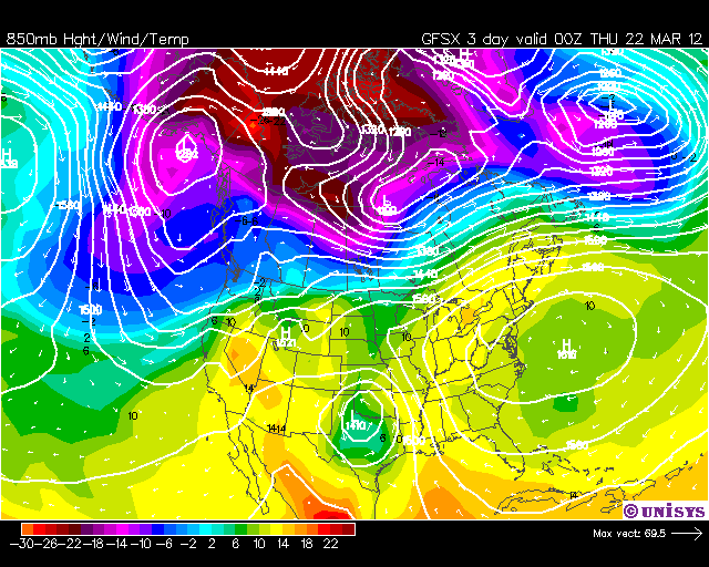
At this level in the atmosphere, meteorologists look at temperatures at roughly 6000 feet. The temperatures at this level are running around 55-66 degrees. This is typical of what you would see in the summer months. This is one way you can forecast warm temperatures. (The orange over the Great Lakes is even warmer air)
Also, a strong west wind around the high pressure will allow winds to flow from the west and West southwest and blow off of the mountains to the west of Boston. As I stated last week, this will allow the air to compress as it comes off the higher hill tops and warm.  Thursday should be a windy day as well and will push the warm air all the way to the coast where a sea breeze will not have an impact on high temperatures.

As shown last week. The mountains to our west will help raise temperatures as a warm west wind will flow over the mountains to the West and warm even more, come Thursday. 
A southwest wind on Thursday will push some ocean cooled air over the south coast and the Cape to keep temperatures lower

It should be of note:  The warmth will leave us come later this weekend and will likely depart and return to just slightly above normal to near normal for the next 10 days after Saturday.

Monday, March 19, 2012

3/19/12 Summer heat to invade New England just as Spring arrives.

I sure hope that many of you enjoyed yesterdays record smashing high temperature of 74 in Boston during the last days of Winter 2012!  That was nothing!! I hope you are ready for some mid to upper 80s by mid week!!

The Vernal (Spring) Equinox begins at 1:14 AM tonight, as we now will have more daylight and less darkness.

Today however, one of those pesky cold ocean backdoor cold fronts will push into coastal New England, providing a sharp line between warmth and chilly air. It will be short lived. Many will see temperatures rise to the lower to mid 60s by noon today, then a backdoor front tries to push westward but only makes it into extreme eastern MA.

A backdoor cold front will start along the coast of MA around Noon and push inland throughout the afternoon, dropping temperatures dramatically. Shown are the temperatures for NOON and 4 PM in areas that will see frontal passage.  Overnight lows will be chilly into the 30s for most areas.  The front reaches the CT river valley by 8 PM.
An extremely strong area of high pressure will win out this week as it pushes warm air into the Northeast US.  The only locations that will not see the warmth will be those on the outer Cape and the Islands where the winds will be blowing over the colder ocean.

A typical summer pattern sets up along the east coast with a Bermuda high bringing in warm air from the Caribbean all the way into New England this week.
The heat arrives on Thursday, full force with highs reaching the mid and upper 80s in some areas. Coastal areas will be much cooler.