 |
Friday, June 10, 2011
6/10/11 A damp weekend, but not a total wash out!
Morning fog will lead to sunshine today and drier air moving in. However moisture will arrive tomorrow and bring the chance for showers and a late day thunderstorm. Rain should hold off until late afternoon and be light in nature until late.
Thursday, June 9, 2011
Severe Thunderstorm Watch

...SOME THUNDERSTORMS WILL LIKELY BECOME SEVERE THIS AFTERNOON AND
EVENING IN SOUTHERN NEW ENGLAND...

THUNDERSTORMS WITH DAMAGING WINDS AND LARGE HAIL ARE POSSIBLE OVER
SOUTHERN NEW ENGLAND FROM MID AFTERNOON THROUGH THE EVENING.  IN
ADDITION...VERY HEAVY RAINFALL MAY CAUSE LOCALIZED URBAN AND POOR
DRAINAGE FLOODING. SOME POOR DRAINAGE LOCATIONS SUCH AS UNDERPASSES
MAY FILL UP WITH WATER QUICKLY AND BE UNSAFE TO DRIVE THROUGH.

THESE THUNDERSTORMS WILL LIKELY ALSO CONTAIN FREQUENT CLOUD TO
GROUND LIGHTNING...A VERY SERIOUS THREAT TO ANYONE CAUGHT OUTDOORS
ON LAND OR WATER.

THE THUNDERSTORMS WILL BE MOST LIKELY BETWEEN 3 AND 7 PM FOR
SOUTHWEST NEW HAMPSHIRE...CENTRAL AND WESTERN MASSACHUSETTS...AND
NORTHERN CONNECTICUT. ACROSS EASTERN MASSACHUSETTS AND RHODE
ISLAND...THE MOST LIKELY TIME PERIOD FOR THE THUNDERSTORMS WILL BE
BETWEEN 5 AND 9 PM.
5/09/11 Near Record Highs today..
One problem with forecasting for locations on the colder ocean is, how will the ocean affect temperatures. Yesterday a good sea breeze set up again for many coastal towns, keeping temperatures in the 70s while just inland some, most people were in the 90s. Today a stronger westerly wind should preclude any onshore winds and keep most areas in the 90s.
Most people want to know about the weekend forecast, so here it is.
For those going to P-town -
Most people want to know about the weekend forecast, so here it is.
 | |
|
For those going to P-town -
 |
| Areas on the Cape will be closer to the moisture source and the threat for showers is greater throughout the weekend. |
 |
| Morning clouds should keep temperatures from reaching the upper 90s as forecast earlier, but it will still be hot and sticky. |
Wednesday, June 8, 2011
6/08/11 Ok. it will be hot for two days!
Hot air will invade New England, but it will not be a heat wave. Today, most areas away from the immediate coast will get into the middle 90s and Thursday will be even hotter.
Dew points will rise, however they will not get to the oppressive levels so humidity will be low during the daytime hours 40%. Nighttime can get sticky.
There is the chance for some strong storms later Thursday with the passage of a cold front. Heavy rain and wind will likely be the biggest concern.
Weekend View - A clear cooler day on Saturday with highs in the lower 70's. Sunday, rain moves in and cloudy with highs in the upper 60s.
 |
| It will be cooler right at the coast and on the Cape |
 |
| Most areas will reach 90+ today. The sea breeze may keep the official temp in Boston from reaching 90. |
 |
| With a stronger west wind temperatures will climb to near 100 degrees for most areas tomorrow. |
Dew points will rise, however they will not get to the oppressive levels so humidity will be low during the daytime hours 40%. Nighttime can get sticky.
There is the chance for some strong storms later Thursday with the passage of a cold front. Heavy rain and wind will likely be the biggest concern.
Weekend View - A clear cooler day on Saturday with highs in the lower 70's. Sunday, rain moves in and cloudy with highs in the upper 60s.
Tuesday, June 7, 2011
Sea Breeze offers natural A/C
A sea breeze moved into eastern MA during the mid-afternoon hours dropping temperatures roughly 12-15 degrees.
The heating of the land allows for the air to rise, this rising air then is replaced by the cooler waters off of the ocean.
 |
| The Sea Breeze can be seen on the radar image as a faint blue line from Boston to Fall River. |
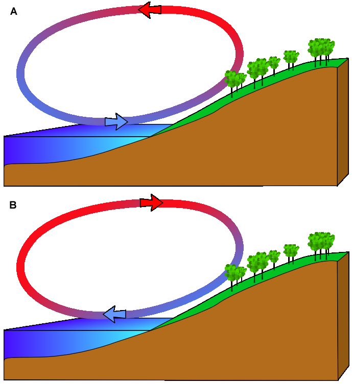 |
| A is a sea breeze. |
6/07/11 Get out the A/C's (if you haven't)
A quick return to hot stick weather is in store for us here in the Boston area. Highs will easily reach the 90's come Wednesday with widespread mid to upper 90's on Thursday. The humidity will also return and nighttime lows will not fall much.
A cold front will approach late on Thursday, bringing thunderstorms. Drier air moves in on Friday and for the weekend clear and much cooler on Saturday (upper 60's) with rain likely on Sunday.
 |
| It will remain in the 80's right along the coast except Tue and Wed. |
 |
| Wednesday's Forecast Highs |
 |
| A very HOT day on Thursday with some interior sections possibly hitting 100 degrees. It will be coolest right at the coast. |
 |
| The Dew Point will rise to the mid to upper 60's by Thursday, making it feel more humid. |
A cold front will approach late on Thursday, bringing thunderstorms. Drier air moves in on Friday and for the weekend clear and much cooler on Saturday (upper 60's) with rain likely on Sunday.
Monday, June 6, 2011
MA Tornado Track on MODIS satellite image
 | |
| Follow to tornado from Springfield to south and west of Worcester. |
and an even better zoomed image is
 |
| Very good track across MA! |
Back to Summer!
 |
| Summer returns with high humidity and heat. A chance exists for an isolated thunderstorm Monday and Thursday. |
There is the possibility of thunderstorms today, mainly along 495 and 95 as the warmer more humid air mass collides with the cooler air along the coast. Severe weather is not expected with the storms.
The flow of air will shift from the ocean to the south and west over the next few days, so we will tap into air from Texas and the Gulf of Mexico.
 |
| Model showing influx of heat in Red stretching from the southwest all the way into the Northeast around an area of high pressure. |
Subscribe to:
Posts (Atom)