I was asked for a forecast for Providence, RI today, so here it is!
Overall - A weak cold front will be pushing through Southern New England today. This will be the focus for some widely scattered showers and thunderstorms and not a complete washout.
Morning fog will give way to a partly sunny sky early. As the daytime heating continues, clouds will develop and by 1 PM the threat for a light shower is expected.
With pop up thunderstorms it is hard to say who will be hit and who will not be hit. The threat for a thunderstorm is from 1pm to about 6pm. With the threat of a continuous shower likely between 1:30 and 3:30 PM Then expect a clearing sky after 6pm as the cool front pushes through and high pressure builds in.
10 AM - Mix Sun and Clouds 71F
12 PM - A few clouds 77F
2 PM - Cloudy, rain or thunderstorm possible 77F
4 PM - Decreasing clouds, a scattered shower 76F
6 PM - Clearing skys 75F
8 PM - Clear and drying out 72F
10 PM - Clear 67F
Saturday, June 18, 2011
Friday, June 17, 2011
6/17/11 Parade Forecast!
An area of showers and thunderstorms will push through during the late morning and early afternoon today. This will not be a total washout, but could be heavy at times.
Hour by Hour Forecast for Saturday (Parade Fans)


Showers and storms will impact the Boston area from around 2PM to 7PM on Saturday. It will be more humid.

Hour by Hour Forecast for Saturday (Parade Fans)

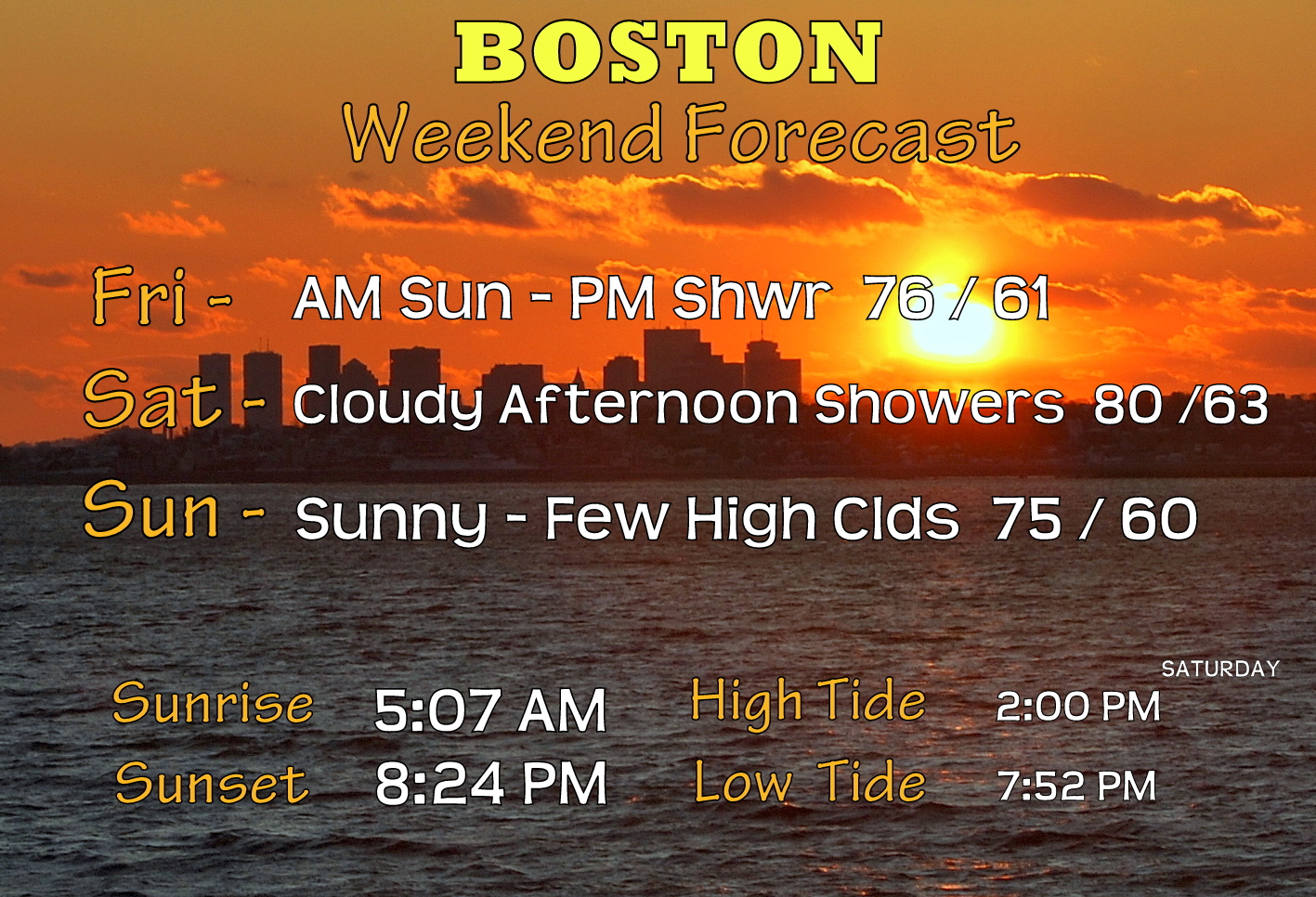
Showers and storms will impact the Boston area from around 2PM to 7PM on Saturday. It will be more humid.

Thursday, June 16, 2011
6/16/11
Summer returns for today with highs in the mid 80s for most areas except the Cape. A west wind will limit any sea breeze.

Friday (for a parade) should not be a total washout, mostly cloudy though with a few breaks of sun here and there. There is the chance for a thunderstorm which could produce heavier showers later in the day.
Saturday - morning rain showers should lessen as the day progresses, it will be a bit humid but cool, esp near the coast with some marine air working in.
Sunday, a mostly sunny day and warmer (cooler Cape)!

Tuesday, June 14, 2011
6/13/11 April like June..
 | |
|
Tuesday looks to be the coolest day that we will have for the next 7-10 days at least.
Wednesday will be cloudy and foggy to start, but the sky should clear some by the afternoon and temperatures rebound nicely to near 70 in Boston, 70's inland.
Thursday, the best day of the week!
 |
| Morning Satellite image - lots of clouds over New England. This area will move out throughout the day today and on Wednesday. |
Weekend at a glance: Saturday - chance of Thunderstorms, mild. Sunday, clearing and a high near 80.
Monday, June 13, 2011
6/13/11 We seem to be stuck...
Wow, what a bust of the forecast overall for the weekend. It rained when I said it wouldn't rain and was dry when I said it would rain. Explanation to follow - but that is to give you an idea on this complicated weather pattern we are in.
Cool damp weather will be with us until Wednesday, followed by a brief warm up. Summerlike weather returns next week.

Monday - Morning breaks in the cloud cover could give us a glimpse of sunshine early today, however clouds will increase today and bring some late afternoon showers. However I do not expect a total washout or period of steady rain.
So the map above, think of your kitchen or bathtub drain, with everything swirling around it collecting all the dirty particles and rotating it around and around. In other words, we get a repetition of weather.
Now here is the same map for Thursday below.
Sinking air scours out the sky, Rising air creates clouds and rain.
Weekend Followup - Basically what happened this weekend, the flow around the areas of low pressure got stalled out even more so than originally thought and the energy came through at different times. There are times when the weather will follow a basic path, or keep on doing what it is doing along its moving path. Other times, small areas can make their own weather where it is more difficult to predict.
Cool damp weather will be with us until Wednesday, followed by a brief warm up. Summerlike weather returns next week.

Monday - Morning breaks in the cloud cover could give us a glimpse of sunshine early today, however clouds will increase today and bring some late afternoon showers. However I do not expect a total washout or period of steady rain.
 | ||
| 850mb - The flow around a stalled/cut off area of low pressure is tapping in cooler air from the North Atlantic near Greenland. The flow is counter clockwise as indicated by the arrows, so an easterly marine flow will keep clouds and some rain showers around. The BLUE color indicates temperature. |
 | ||||||||
| Normally I would not show such a map, this is the weather at 18,000 feet (500mb). But this map is centered over New England. The greens, yellows and reds indicate areas of unsettled weather. (Rising air or energy) With such a flow if this were in motion, the oranges over St. Lawrence are moving west then down over Pennsylvania and then up over Connecticut then out over Maine. |
Now here is the same map for Thursday below.
 |
| Same type of map, only for this Thursday, Notice all of the Blue over New England. (The Reds move away). Blues on this map are calm, settled (sinking air) and usually clear. NOTE Colors are not temperature on this map. |
Sinking air scours out the sky, Rising air creates clouds and rain.
Weekend Followup - Basically what happened this weekend, the flow around the areas of low pressure got stalled out even more so than originally thought and the energy came through at different times. There are times when the weather will follow a basic path, or keep on doing what it is doing along its moving path. Other times, small areas can make their own weather where it is more difficult to predict.
Subscribe to:
Posts (Atom)