But first, a strong southerly flow ahead of a polar air mass will allow temperatures to surge to about 50 today.
On Saturday, what is known at the Polar Vortex, (an area of intense cold, will push south and east and drop temperatures 45-50 degrees by Sunday night from values today)
 | ||
| So here is what is happening... The main jet stream which flows a lot of the weather systems is dipping out of Montana over Texas and then moving up the East Coast. The subtropical Jet stream, which is bringing in moisture from the Pacific Ocean over the Gulf of Mexico and up the east coast is very strong. A branch of the Jet Stream which is bringing in the polar air mass (Jet Stream P) is surging south and eastward. These Jets or storm tracks are going to meet up along the east coast later today into tonight. This will allow a weak storm over the Great Lakes to develop a coastal Nor'Easter off of the Carolinas (which right now is almost non-existant) and move up the coast. |
 |
| For 1 PM on Saturday, the Low pressure intensifies well south of New England at its closest approach. A strong high over Quebec will bring in the colder air while a Stronger high over Nebraska will usher in the colder air for 2/3 of the country. weatheronline.co.uk |
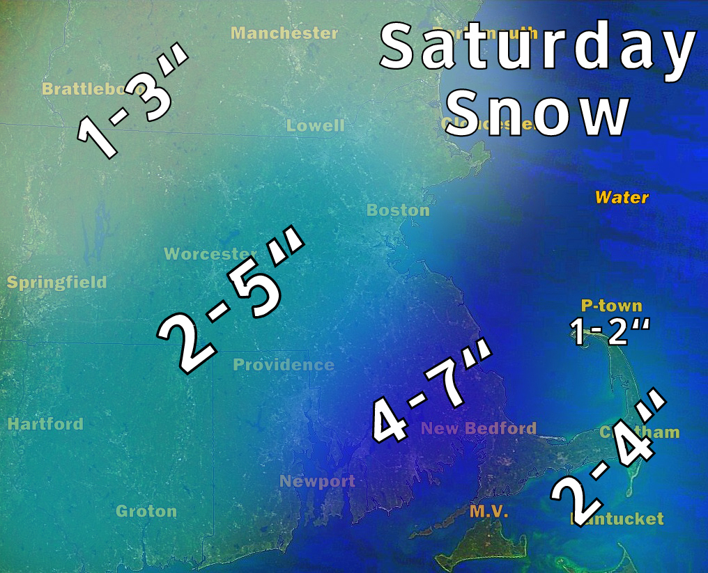 |
| Snowfall amounts. With the storm traveling far south a major snowstorm is not foreseen, but the heaviest snow will fall south of Boston from Providence - Brockton- . Lighter amounts will fall on the immediate coastline and just north/south of the Pike and in Boston expect up to 4 inches. Lesser amounts in NH and the Berkshires. The cold air will be late in arriving on the extreme south shore and Cape and therefore the precipitation will begin as rain and continue for most of the storm. Therefore lesser amounts are forecast with a brief changeover later on the outer Cape. |
Snow will start to fall late Friday night and into the early morning Saturday with the heaviest arriving at Sunrise until around 1 PM.
 |
| High temperatures for Saturday.. Cold air aloft will support snowfall except on the south coast at first. Temperatures will fall throughout the afternoon. |
 |
The snow will end by sunset on Saturday. After that, cold air (in the red and oranges and purples) will push into New England and down the East coast allowing for a very COLD windy day on Sunday and Sunday night! Likely the coldest of this winter season. |
No comments:
Post a Comment