My Personal Weather Station

Weather at Boston, Logan International Airport, MA - via NOAA's National Weather Service

Current Watches, Warnings and Advisories for Massachusetts Issued by the National Weather Service

Tuesday, December 6, 2011

12/6/11 It's Going to Feel more Like Christmas

Colder air is on the way, but we will have one more day of temperatures in the mid 60s!!

Rain and drizzle will be with us for the next 48 hours as a cold front slowly pushes through the area to bring in some more seasonable temperatures for early December.


A coastal storm will likely pass out to sea on Thursday and remain weak and will just give a brief shower. Some higher elevations could see some snow or sleet.

A clipper system pushes by on Saturday to possibly squeeze out some snow showers.

Thursday, December 1, 2011

12/1/11 A calmer, cooler period ahead.

As we enter December, we can expect some December like temperatures.  Overall we will be closer to normal today than we have been.

December weather highlights!
The weather pattern is in a quiet mode with the exception of a weak cold front over the plains. This will push through tonight and bring in a push of cooler air, but no major cold outbreaks. I foresee this being a pattern at least until later next week, when it becomes more amplified, a push of cold, followed by a return to mild and back and forth. 

A cold front in the middle of the country will bring cooler air from Montana into New England for Saturday


A significant push of colder air will come in next Wednesday into Thursday in which it will be cold, but short lived. This push though will change the weather pattern to one of more possible storms moving up the coast, something we have not seen in a few weeks. More to come....


Monday, November 28, 2011

11/29/11 A humid November day???

Does that sound right? Humid November day?  Yes, warm moist air is being transported from the deep south into New England today. Dew Point temperatures will reach the mid 50s, so yes, you may feel a bit sweaty today when walking around in the mild air!

Today - Mild, humid south wind high of 65!

Tonight - Rain arrives, heavy at times, low of 59!!

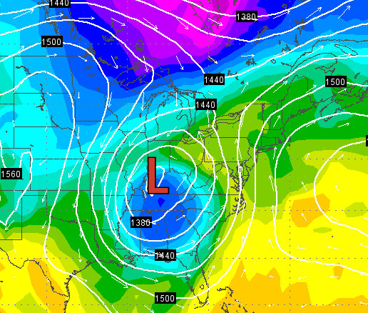
A large storm over the South is allowing warm air to flow north into New England today as it winds up!
A map of temperatures of the image above showing a cold pool over the south, cut off from the main flow of the jet stream.
A complicated weather map this morning, with the RADAR. Blue areas are snow. It is snowing in Mississippi, Georgia, North Carolina where it will be in the 60s in Boston today.   A cold front will keep northern New England cooler as it retreats north during the day as a warm front. The rain will push through overnight tonight. The Cold Front over the Great Lakes is a kicker and will push this mess away during the day on Wednesday and bring in cooler air
Next week we can look forward to more December like weather as colder air flows in from Canada, however I do not see a pattern of extreme cold where mild days will ebb and flow with the cold.

Tuesday, November 22, 2011

11/22/11 Pre Turkey Day Storm!

A cold start to the morning today with many locations in the lower teens in NH VT and Maine, Boston was 34, due to the ocean air, but just inland temperatures fell way below freezing.
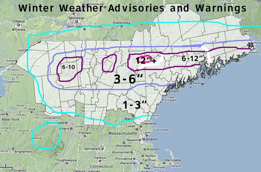
This cold air mass will help set up a major storm for the evening tonight into Wednesday, especially for areas north of Boston.

Up to a foot of snow could fall in some areas!  Luckily for those traveling in MA, it will be too warm and rain will fall.  However, a change over to light snow at the very end of the storm late Wed night is possible for all areas.

Travel north into NH, VT or Maine could be tricky and treacherous.

The storm will not be a typical Nor'easter however, as it will be already developed as seen on the satellite image this morning over Missouri. There is not a dip in the jet stream to have it ride up the coast or get a lot of energy from the Atlantic Ocean.

Weather map for mid day Wednesday showing the low track south of Cape Cod, heavy rain is expected in Mass. Colder air will filter in behind this storm to bring light snow showers,
Most of the east from the Rockies to the Atlantic will be sunny!  Rain in the Pacific coast and Snow in the northern Rockies at high elevations!


As a note, the cold arctic air that is building in Alaska will be making a dip south come December!

Sunday, November 20, 2011

11/20/11 More warmth...

A 65 degree day in November is a very nice treat. Isn't odd how we think of this as being warm, when in July, 65 for a high would be a chilly day?   Then again too a July 65 would be very humid and sticky, today will be nice and dry.


A strong breeze from the southwest ahead of a cold front will bring in the warm temperatures, winds could gust as high as 40 mph on the Cape later today!!

Most areas across Massachusetts will be in the 60s today!
A cold front will push through late tonight into Monday morning, bringing in a much cooler airmass for the week. However the weather pattern is very zonal and there are no major dips to bring the cold air in with a rush, so most of it will stay locked in Canada.
Temperatures will fall to the 40s by Monday.

A potential strong rain storm will approach New England on Wednesday, with wind and heavy rain. It will be warm ahead of the front. Cold air wraps in behind the storm and will likely end as a light snowfall.  Heavy snow could fall in Northern Maine and New Brunswick and Quebec.

Travel will be hampered on Wednesday with a heavy rains.

Tuesday, November 15, 2011

11/15/11 More milds... then a cool off.

60 Degrees at 7 AM in Boston on November 15. Wow, considering the average high for today is 52, 60 is quite warm. This would be a normal morning in June!

We can thank a cold front off to our west for allowing warm air to surge ahead of it. This cold front will continue to slowly push eastward and the low pressure that is associated with it will strengthen some once it reaches the Atlantic Ocean.


A shield of rain will develop along the front and stream into New England on Wednesday for a pretty damp day.

Weather map for Wednesday showing rain over much of southern New England at 2 PM. The rain will be around most of the day

The colder air will begin to pour into the northeast on Thursday where we will be left dry but cooler.  Warmer air returns for the later part of the weekend!


Monday, November 14, 2011

11/14/11 Enjoying some warmth!

What should have transpired in October is now happening in November. A transitional period... Yeah yeah, we already had snow and a frost, but what will be happening over the next 10 days will be a surge of warmth, followed by some cold, then warming again. No long term cold spell are in the forecast.

Cold air building in Canada will try to make a run into the Northeast later in the week, but strong High pressure will reinforce its self to our south and allow warmer air to return

What I am seeing however is this pattern will remain until Thanksgiving, arctic air will build tough in Alaska and the Yukon as night begins its winter stay. This air will eventually push south but likely not until December.

The jet stream over the next 10 days will be zonal, keeping colder air north and warm air south. Small dips or rises will dictate our weather but no major dips are foreseen to produce large storms or a cold outbreak.