 |
| Irene at 10PM August 25. |
Well my friends, there are 2 possible tracks that Irene could take. Usually we are talking about the track out to sea or the track just over Boston. However this time, the track over Boston seems the least likely of the track as it appears to be going further WEST, over Long Island and CT.
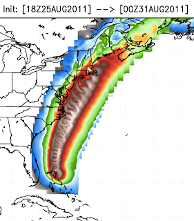
One model run that I like and displays the hurricane well is below.
 |
| The white areas show hurricane force winds with one of the models tracking furthest east over Boston. This is still a very good probability. |
However, there is also a cluster of models that track Irene directly over New York City. This would still give Boston some good winds up to 65-75 mph, but not as bad. This is the worst case scenario possible and if this comes to be, NYC and Long Island will never be the same again. It has been posted that the highrise sky scrapers could experience with an 80mph hurricane winds over 120 at the highest floors.
What I would like to say now tho is, Irene is HUGE! If I were to super-impose Irenes winds field over New England right now, the extent of Tropical Storm force winds would stretch from P-town to the Finger Lakes in NY, almost 375 miles across would get tropical storm force winds and hurricane winds extend out 130 miles across, a very large hurricane.
Where am I leaning with my forecast on Irene. I do think that a gradual nudge to the east will take place and Boston will be in for a rough time.
Rain will begin Saturday evening and continue until the hurricane passage Monday morning.
Tropical Storm force winds (>39mph arrive around 7 AM on the south shore of RI and MA and Cape Cod. Boston - 9-11 AM.
Hurricane conditions arrive at 1 PM on the south coast and the eye makes landfall between mid Long Island and Newport, RI at 2 PM.
The eye of Irene tracks near or close to Boston around 3-5 PM, with winds possibly up to 80 mph.
I cannot discount the track over NYC, but I think Irene will be nudged further east at this time.


Thanks Bryan!
ReplyDelete