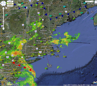
Not much new to say today folks. The rain is with us at least until Friday and finally clearing out Saturday with Sunday looking to be a great day. Temperatures will be cool for another day or so, but as the pesky low begins to weaken temperatures should moderate back into the lower 60's.
The low will be slow to move, but come Friday much of the rain will push away as an area of high pressure from Canada will move in. However with such an unstable airmass in place, a spot shower on Friday and Saturday cannot be ruled out, but it will not be a washout. Another key factor too will be the winds. The have been and will be coming in from the east off the ocean, by Friday they shift to the south and west, (typically a drying warming wind)
Weekend Forecast
Friday - High 65 Chance of a shower mostly cloudy
Saturday - High 67-72 slight chance of a pop up shower
Sunday - High 74-79 Partly to mostly sunny

No comments:
Post a Comment